Apple deal with China included misrepresenting land size in Apple Maps

#1

AshG

Easy target
Joined
Nov 5, 2008
Messages
8,374
Likes
7,400
#1
Apple CEO Tim Cook reportedly signed a secret $275 billion deal with China in 2016 to skirt challenges with government regulators

"Outside of the deal, Apple made other concessions with the Chinese government to keep business running. By early 2015, China's State Bureau of Surveying and Mapping had directed Apple Maps to make the Diaoyu Islands, or Senkaku Islands, which China and Japan both claim to own, look big even when zoomed out; regulators said they'd refuse to approve the Apple Watch if Apple didn't comply, according to internal documents viewed by The Information. The company ultimately accommodated the demand."
 
  • Like
Reactions: lukeneyland
#2
#2
Apple CEO Tim Cook reportedly signed a secret $275 billion deal with China in 2016 to skirt challenges with government regulators

"Outside of the deal, Apple made other concessions with the Chinese government to keep business running. By early 2015, China's State Bureau of Surveying and Mapping had directed Apple Maps to make the Diaoyu Islands, or Senkaku Islands, which China and Japan both claim to own, look big even when zoomed out; regulators said they'd refuse to approve the Apple Watch if Apple didn't comply, according to internal documents viewed by The Information. The company ultimately accommodated the demand."

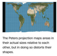
What really gets me is these new maps that portray NA as smaller and Africa such a huge continent. Hmmmm
 
#5
#5
Apple CEO Tim Cook reportedly signed a secret $275 billion deal with China in 2016 to skirt challenges with government regulators

"Outside of the deal, Apple made other concessions with the Chinese government to keep business running. By early 2015, China's State Bureau of Surveying and Mapping had directed Apple Maps to make the Diaoyu Islands, or Senkaku Islands, which China and Japan both claim to own, look big even when zoomed out; regulators said they'd refuse to approve the Apple Watch if Apple didn't comply, according to internal documents viewed by The Information. The company ultimately accommodated the demand."
They do similar with their driving maps and apps. Non approved ones the directions are off on purpose. You have to get government approved apps inside of china to get real directions.
 
#8
#8
#13
#13
You mean the ones where they correct for the spherical nature of the globe? Africa is 20% bigger than NA, almost 2 million square miles more so.

You misunderstood my post...Of course Africa is huge and the laying of a sphere onto a 2-D image will distort actual landmass depending on the view axis. Does this look like 20% more land area? Of course it is political to view Africa as bigger than sit really is with a map...well we know

What's the real size of Africa? How Western states used maps to downplay size of continent | CNN

Screen Shot 2021-12-08 at 5.23.15 PM.png
 
  • Like
Reactions: AshG
#14
#14
You misunderstood my post...Of course Africa is huge and the laying of a sphere onto a 2-D image will distort actual landmass depending on the view axis. Does this look like 20% more land area? Of course it is political to view Africa as bigger than sit really is with a map...well we know

What's the real size of Africa? How Western states used maps to downplay size of continent | CNN

View attachment 418782
For comparison... This is purportedly the size of the countries/continents in Mercator projection vs reality.
mercator-true-size.jpg
 
  • Like
Reactions: DC_Vol
#16
#16
For comparison... This is purportedly the size of the countries/continents in Mercator projection vs reality.
mercator-true-size.jpg

By landmass, does Africa look 20% bigger with the actual? Of course not...it is political just as Mercator.

Just look at Canada....you think landmass of US is equivalent? And Alaska...lol
 
#18
#18
By landmass, does Africa look 20% bigger with the actual? Of course not...it is political just as Mercator.

Just look at Canada....you think landmass of US is equivalent? And Alaska...lol
By landmass, does Africa look 20% bigger with the actual? Of course not...it is political just as Mercator.

Just look at Canada....you think landmass of US is equivalent? And Alaska...lol
Canada Or USA: Which Country Is Larger In Terms Of *Land* Area (Excluding Water) ? - Flytrippers

Also check out image 15 on the link in my previous post.
 
#19
#19

Intersting for sure and looks to point out the northern hemisphere 2D perspective where the closer the nation or area is the the view axis, the bigger it looks to the off axis. I still have a problem with landmass of Africa being only 20% bigger landmass than NA, when the "actual" view that was posted shows that to not be the case, especially with the diminished size of Canada when omitting "lakes"

Just bizarre to me that in 21st century this all the sudden is a realization, hence my political opinion,

Maybe the world should not be so concerned with the issue of climate change sea levels if land based glaciers are possibly using flawed methods.
 
#20
#20
Intersting for sure and looks to point out the northern hemisphere 2D perspective where the closer the nation or area is the the view axis, the bigger it looks to the off axis. I still have a problem with landmass of Africa being only 20% bigger landmass than NA, when the "actual" view that was posted shows that to not be the case, especially with the diminished size of Canada when omitting "lakes"

Just bizarre to me that in 21st century this all the sudden is a realization, hence my political opinion,

Maybe the world should not be so concerned with the issue of climate change sea levels if land based glaciers are possibly using flawed methods.
I think the image is a little deceptive because you don't see the actual parts of the North American landmass together. If you were to put them together and superimpose them over the African land mass, it probably wouldn't be as far off as you think.

Edit: (I'm referencing the blue contrast map I posted).
 
Last edited:
  • Like
Reactions: Orangeburst
#21
#21
I think the image is a little deceptive because you don't see the actual parts of the North American landmass together. If you were to put them together and superimpose them over the African land mass, it probably wouldn't be as far off as you think.

I considered that a few times as I looked. Hey if that is an actual landmass representation then I have to agree. But is Greenland and Antartica really that small? If so is this CC sea level risings with land borne melting glaciers accurate?
 
#22
#22
I considered that a few times as I looked. Hey if that is an actual landmass representation then I have to agree. But is Greenland and Antartica really that small? If so is this CC sea level risings with land borne melting glaciers accurate?
I can certainly see how Antartica, Greenland, and the Canadian islands would be greatly skewed in the Mercator projection.

I dont know much about climate change arguments. I guess if you think about it, losing the northern polar ice cap might be a bigger deal than we tend to think because we assume those landmasses are so big leaving less room for the ice cap.
 
#23
#23
I can certainly see how Antartica, Greenland, and the Canadian islands would be greatly skewed in the Mercator projection.

I dont know much about climate change arguments. I guess if you think about it, losing the northern polar ice cap might be a bigger deal than we tend to think because we assume those landmasses are so big leaving less room for the ice cap.


I always assumed the northern ice cap is irrelevant to rising sea levels..ie water and ice displacement is same.
 

VN Store


Back
Top