East Tennessee Weather II

Alert!!!!!!!!!!!!!

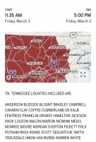
...HIGH WIND WARNING IN EFFECT FROM 10 AM FRIDAY TO 1 AM EST
SATURDAY...

* WHAT...Southwest winds 25 to 40 mph with gusts up to 60 mph
expected.

* WHERE...Northern Plateau and Central Tennessee valley.

* WHEN...From 10 AM Friday to 1 AM EST Saturday.

* IMPACTS...Damaging winds will blow down trees and power lines.
Widespread power outages are expected. Travel will be
difficult, especially for high profile vehicles.

* ADDITIONAL DETAILS...The saturated ground will make conditions
more susceptible to down trees.
 
MRX discussion

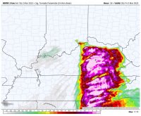
"For Friday, the upper level system and associated strong
cyclogenesis will lift northeast toward the Ohio valley.
Impressive 850-700mb jet with NAEFS showing anomaly high wind
field over the Tennessee valley. The 850mb jet of 75kts+ will move
across the region with strong momentum transfer of the low-level
jet to the surface. Even though the wind gusts of 50-60 mph in the
valley may be below warning criteria, saturated ground will make
conditions more susceptible to down trees and power lines. Power
outages Friday are likely.

Beside the gradient induced high winds, a severe threat also
exists. Damaging straight line will be the main concern. Isolated
tornadoes are also possible as 0-1km and effective shear are off
the charts.
Limiting factors are the low-CAPE and possible high
LCL heights. Also, the strongest of the synoptic forcing lift
north of the area.

Will need to monitor the potential of tornadoes closely. Latest
HRRR model does show an increasing potential but HREF CAMS showed
the best 2-5km updraft helicity tracks over Kentucky."
 
The biggest question mark as far as severe weather goes (especially tornadoes) is how much instability will be present.
 
The biggest weather story tomorrow is going to be the strong to damaging wind gusts that we will likely see outside of thunderstorms. High Wind Warnings for all of East TN is a very rare event. What makes it worse is with the ground being saturated, wind gusts as little as 45 mph could knock down trees. I do think there will be a good number of power outages tomorrow, and I would highly recommend moving any loose objects outside into a secured area.
 
Heard Todd Howell say this is the first time since December 2006 that all of East Tennessee is under a high wind warning
 
Update:

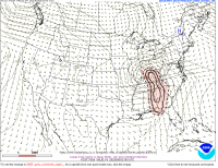
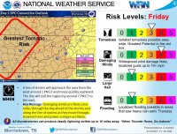
The western 2/3rd of East TN (areas along and west of Morristown) have been upgraded to an enhanced risk. This is primarily due to the increasing threat for damaging to potentially destructive straight line winds up to 80 mph. As I said last night, the very strong wind gusts (in and out of thunderstorms) is going to be the biggest weather story.
 
Heads up!

If you have a NOAA weather radio, be aware that the Knoxville Radio station is down. Make sure to have multiple ways to receive watches and warnings on your devices.
 
Update!

All of East TN is now under an enhanced risk for strong to severe storms. Also, the Plateau is now included in the 10% hatched tornado risk area. There could be an isolated strong tornado or 2 (EF-2 or EF-3) in the Cumberland Plateau this afternoon.
 
Thank you guys for posting the tornado watch. I'll be going into work around 2:00, so I might not be able to stay on top of the warnings issued.
 
Looks like the line of storms is starting to break up into more discrete cells. This increases likelihood of tornadoes.
 
Here is the info from the Tornado watch:

The NWS Storm Prediction Center has issued a

* Tornado Watch for portions of
Northern Alabama
Northwest Georgia
Extreme southwest North Carolina
Eastern Tennessee

* Effective this Friday morning and afternoon from 1035 AM until
400 PM CST.

* Primary threats include...
A few tornadoes likely with a couple intense tornadoes possible
Scattered damaging winds likely with isolated significant gusts
to 80 mph possible
 
Alert!!!!!!!!!!!!!!!!!! (Folks in the Chattanooga area need to be prepared to go into your safe area)

The National Weather Service in Morristown has issued a

* Tornado Warning for...
Central Marion County in east Tennessee...

* Until 1245 PM CST.

* At 1221 PM CST, a severe thunderstorm capable of producing a
tornado was located 10 miles north of Stevenson, or 10 miles
northwest of Bridgeport, moving northeast at 65 mph.

HAZARD...Tornado.

SOURCE...Radar indicated rotation.

IMPACT...Flying debris will be dangerous to those caught without
shelter. Mobile homes will be damaged or destroyed.
Damage to roofs, windows, and vehicles will occur. Tree
damage is likely.

* This dangerous storm will be near...
South Pittsburg around 1230 PM CST.
Kimball around 1235 PM CST.
Jasper around 1240 PM CST.
Whitwell around 1245 PM CST.

Other locations impacted by this tornadic thunderstorm include Martin
Springs, Sequatchie Cave, Foster Falls State Park, Griffith Creek,
Chimneys State Park, Powells Crossroads, Orme, Fiery Gizzard State
Park and New Hope.
 
law enforcement confirmed tornado on the ground near Scottsboro, AL. This line of storms is heading towards East Tennessee
 
Alert!!!!!!!!!!!!

The National Weather Service in Morristown has issued a

* Severe Thunderstorm Warning for...
Sequatchie County in east Tennessee...
Southwestern Bledsoe County in east Tennessee...
Eastern Marion County in east Tennessee...
Central Hamilton County in east Tennessee...

* Until 245 PM EST/145 PM CST/.

* At 137 PM EST/1237 PM CST/, a severe thunderstorm was located over
Whitwell, or 12 miles northeast of Jasper, moving northeast at 40
mph.

HAZARD...70 mph wind gusts.

SOURCE...Radar indicated.

IMPACT...Expect considerable tree damage. Damage is likely to
mobile homes, roofs, and outbuildings.

* Locations impacted include...
Chattanooga, Dunlap, Jasper, Pikeville, Soddy-Daisy, Signal
Mountain, Walden, Lakesite, Whitwell and Kimball.
 

VN Store


Back
Top