Before the center of the storm reaches us this evening, here's my official forecast for tropical storm Nate.
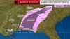
Rainfall amounts and flood threat: 1-3 inches with isolated 4+ amounts possible, especially south of I-40. Foothills could experience a "rain shadow" or downsloping effect where there won't be as much rain due to the NE winds. The flooding threat will be localized due to the very dry ground across the area.
Wind: As I said in my last post, the valley will see gusts up to 40 mph (maybe 45+ mph on ridges), while the mountains above 3000 feet could see gusts up to 60 mph. I'm not anticipating widespread power outages, but isolated power outages are possible (the mountains will have a greater chance of seeing power outages). The stronger winds will arrive once the center of Nate enters TN.
Severe threat: I can't say that the tornado threat is absolute zero, but with little to no surface heating due to the cloud cover and rain, the threat is very low. I'm not really concerned about this.

")