East Tennessee Weather II

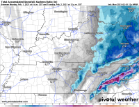
Hey Met, what are you thinking about Sunday-Monday? Weather Channel this morning showed how different the GFS and Euro are for our area, with the Euro giving us snow. I checked the CMC and it is also showing some possible snow for us in East TN.
 
So what’s this system looking to do in the valley Monday? Sounding like big time snow in the mountains. Any chance we get some decent accumulation in the valley?
 
Northwest flow machine going to be cranking out snow across the higher elevations, but probably won't get much in the valley today. A few valley spots could get up to an inch. Unless temperatures are very cold (as in the mountains), the increasing solar radiation in February and beyond makes it difficult to accumulate much during the daytime hours.
1612186916616.png
 
  • Like
Reactions: davethevol
Northwest flow machine going to be cranking out snow across the higher elevations, but probably won't get much in the valley today. A few valley spots could get up to an inch. Unless temperatures are very cold (as in the mountains), the increasing solar radiation in February and beyond makes it difficult to accumulate much during the daytime hours.
View attachment 347460

That map pretty much nailed it. May see some lingering snow showers that could accumulate after sunset but very little verification for that. Weekend storm could be a doozy. Another wait and see where the low goes.
 
  • Like
Reactions: MetVol
That map pretty much nailed it. May see some lingering snow showers that could accumulate after sunset but very little verification for that. Weekend storm could be a doozy. Another wait and see where the low goes.

RT, how are the temps looking for the weekend?
 
That map pretty much nailed it. May see some lingering snow showers that could accumulate after sunset but very little verification for that. Weekend storm could be a doozy. Another wait and see where the low goes.
Yeah I don't know how much moisture this weekend, but it looks cold.
 
Wow LOL

1225521152_ScreenShot2021-02-01at2_06_47PM.png.718d7b3f7b3e4452119768529f552091.png
 
  • Like
Reactions: headhunter15
Haha. Way too early but it does look like this weekend and next week could get interesting for East TN.
Definitely looks interesting. I'll say this: systems like we've had the past couple days are a real pattern shifter. This wave amplification will lead to some much colder air for the next couple weeks for the Eastern US. Last time we had some "big" snowfall in the valley was back in February 2015 during a similar late winter pattern.
 
Trying to do a little hiking and camping next weekend. Don’t mind the snow, but bitterly cold rain kinda blows.
 
  • Like
Reactions: VolNExile
It seems all the East TN forecasts suddenly changed for early next week and now we aren’t supposed to get hit or very little. Even in the mountains it looks like they aren’t calling for much snow if any. What changed? Is it different timing now? They seemed pretty sure that system was coming.
 
It seems all the East TN forecasts suddenly changed for early next week and now we aren’t supposed to get hit or very little. Even in the mountains it looks like they aren’t calling for much snow if any. What changed? Is it different timing now? They seemed pretty sure that system was coming.

They'll change 75875576444 times before then. No worries. Even the day of they'll change the forecast about 35 times
 
  • Like
Reactions: hUTch2002
It seems all the East TN forecasts suddenly changed for early next week and now we aren’t supposed to get hit or very little. Even in the mountains it looks like they aren’t calling for much snow if any. What changed? Is it different timing now? They seemed pretty sure that system was coming.
I've lived and worked around here long enough to never be too certain of a deterministic forecast 5-7+ days out, especially in the winter. A lot can, and usually does, change. Looks like it'll still be colder than normal, but the coldest air may remain north with the main surface low to our south.
 
  • Like
Reactions: hUTch2002
I've lived and worked around here long enough to never be too certain of a deterministic forecast 5-7+ days out, especially in the winter. A lot can, and usually does, change. Looks like it'll still be colder than normal, but the coldest air may remain north with the main surface low to our south.

That was crazy to see the GFS and Euro both take away the frigid cold today. Looks like the moisture could be gone, too.

The GFS and CMC are showing brutal cold the week after next, but who knows anymore? Haha
 
  • Like
Reactions: MetVol

VN Store


Back
Top