East Tennessee Weather II

Severe Weather Statement
National Weather Service Morristown TN
108 PM EDT Fri May 6 2022

TNC025-061730-
/O.CON.KMRX.TO.W.0002.000000T0000Z-220506T1730Z/
Claiborne TN-
108 PM EDT Fri May 6 2022

...A TORNADO WARNING REMAINS IN EFFECT UNTIL 130 PM EDT FOR
NORTHWESTERN CLAIBORNE COUNTY...

At 108 PM EDT, a severe thunderstorm capable of producing a tornado
was located near Fonde, or near Middlesboro, moving northeast at 35
mph.

HAZARD...Tornado.

SOURCE...Radar indicated rotation.

IMPACT...Flying debris will be dangerous to those caught without
shelter. Mobile homes will be damaged or destroyed. Damage
to roofs, windows, and vehicles will occur. Tree damage is
likely.

This dangerous storm will be near...
Harrogate around 125 PM EDT.

Other locations impacted by this tornadic thunderstorm include
Cumberland Gap.

PRECAUTIONARY/PREPAREDNESS ACTIONS...

TAKE COVER NOW! Move to a basement or an interior room on the lowest
floor of a sturdy building. Avoid windows. If you are outdoors, in a
mobile home, or in a vehicle, move to the closest substantial shelter
and protect yourself from flying debris.
 
Severe Thunderstorm Warning
TNC009-093-155-061815-
/O.NEW.KMRX.SV.W.0016.220506T1727Z-220506T1815Z/

BULLETIN - IMMEDIATE BROADCAST REQUESTED
Severe Thunderstorm Warning
National Weather Service Morristown TN
127 PM EDT Fri May 6 2022

The National Weather Service in Morristown has issued a

* Severe Thunderstorm Warning for...
Southeastern Knox County in east Tennessee...
Northern Blount County in east Tennessee...
West central Sevier County in east Tennessee...

* Until 215 PM EDT.

* At 126 PM EDT, a severe thunderstorm was located 8 miles southwest
of Maryville, moving northeast at 40 mph.

HAZARD...60 mph wind gusts and quarter size hail.

SOURCE...Radar indicated.

IMPACT...Hail damage to vehicles is expected. Expect wind damage
to roofs, siding, and trees.

* Locations impacted include...
Knoxville, Maryville, Alcoa, Louisville, Rockford, Eagleton
Village, Greenback, Friendsville, Kimberlin Heights and Wildwood.

This includes Interstate 40 in Tennessee between mile markers 395 and
398.

PRECAUTIONARY/PREPAREDNESS ACTIONS...

For your protection move to an interior room on the lowest floor of a
building.
 
  • Like
Reactions: Vol knight
The National Weather Service in Morristown has issued a

* Severe Thunderstorm Warning for...
Northeastern Knox County in east Tennessee...
Northwestern Jefferson County in east Tennessee...
Grainger County in east Tennessee...
Southeastern Union County in east Tennessee...
West central Hamblen County in east Tennessee...

* Until 230 PM EDT.

* At 144 PM EDT, a severe thunderstorm was located near Plainview, or
9 miles south of Maynardville, moving northeast at 45 mph.

HAZARD...60 mph wind gusts and penny size hail.

SOURCE...Radar indicated.

IMPACT...Expect damage to roofs, siding, and trees.

* Locations impacted include...
Morristown, Rutledge, Plainview, New Market, Blaine, Luttrell,
House Mountain State Park, Panther Creek State Park, Maloneyville
and Mascot.

PRECAUTIONARY/PREPAREDNESS ACTIONS...

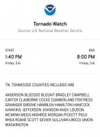
A Tornado Watch remains in effect until 800 PM EDT for east
Tennessee.

For your protection move to an interior room on the lowest floor of a
building.

A Tornado Watch remains in effect until 800 PM EDT for east
Tennessee.
 
The National Weather Service in Morristown has issued a

* Severe Thunderstorm Warning for...
Loudon County in east Tennessee...
Southwestern Knox County in east Tennessee...
Northwestern Blount County in east Tennessee...
Northwestern Monroe County in east Tennessee...
Southeastern Roane County in east Tennessee...

* Until 245 PM EDT.

* At 155 PM EDT, a severe thunderstorm was located near Sweetwater,
moving northeast at 30 mph.

HAZARD...60 mph wind gusts and quarter size hail.

SOURCE...Radar indicated.

IMPACT...Hail damage to vehicles is expected. Expect wind damage
to roofs, siding, and trees.

* Locations impacted include...
Oak Ridge, Lenoir City, Sweetwater, Loudon, Farragut, Louisville,
Friendsville, Philadelphia and Tellico Village.

This includes the following highways...
Interstate 40 in Tennessee between mile markers 361 and 373.
Interstate 75 in Tennessee between mile markers 61 and 84.

PRECAUTIONARY/PREPAREDNESS ACTIONS...

A Tornado Watch remains in effect until 800 PM EDT for east
Tennessee.

For your protection move to an interior room on the lowest floor of a
building.

A Tornado Watch remains in effect until 800 PM EDT for east
Tennessee.
 
Alert!!!!!!

The National Weather Service in Morristown has issued a

* Severe Thunderstorm Warning for...
East central Knox County in east Tennessee...
Jefferson County in east Tennessee...
Northwestern Sevier County in east Tennessee...
Southwestern Hamblen County in east Tennessee...

* Until 245 PM EDT.

* At 202 PM EDT, a severe thunderstorm was located near Sevierville,
moving northeast at 45 mph.

HAZARD...60 mph wind gusts and quarter size hail.

SOURCE...Radar indicated.

IMPACT...Hail damage to vehicles is expected. Expect wind damage
to roofs, siding, and trees.

* Locations impacted include...
Morristown, Sevierville, Jefferson City, Dandridge, White Pine, New
Market, Baneberry, Panther Creek State Park, Kimberlin Heights and
McMahan.

This includes the following highways...
Interstate 40 in Tennessee between mile markers 401 and 429.
Interstate 81 in Tennessee between mile markers 1 and 6.
 
Alert!!!!!!

The National Weather Service in Morristown has issued a

* Severe Thunderstorm Warning for...
Southwestern Loudon County in east Tennessee...
Central McMinn County in east Tennessee...
Northwestern Monroe County in east Tennessee...

* Until 300 PM EDT.

* At 215 PM EDT, a severe thunderstorm was located over Athens,
moving northeast at 35 mph.

HAZARD...60 mph wind gusts and quarter size hail.

SOURCE...Radar indicated.

IMPACT...Hail damage to vehicles is expected. Expect wind damage
to roofs, siding, and trees.

* Locations impacted include...
Athens, Sweetwater, Loudon, Madisonville, Englewood, Vonore, Niota,
Philadelphia, Fort Loudon State Park and McGee Carson Peninsula.

This includes Interstate 75 in Tennessee between mile markers 46 and
74.
 
Alert!!!!!!!

The National Weather Service in Morristown has issued a

* Flash Flood Warning for...
Northwestern Blount County in east Tennessee...
Knox County in east Tennessee...
Loudon County in east Tennessee...
Northwestern Monroe County in east Tennessee...
Northwestern Sevier County in east Tennessee...

* Until 630 PM EDT.

* At 223 PM EDT, Doppler radar indicated thunderstorms producing
heavy rain across the warned area. Up to 1.5 inches of rain have
fallen. Additional rainfall amounts up to 2 inches are possible in
the warned area. Flash flooding is ongoing or expected to begin
shortly.

HAZARD...Flash flooding caused by thunderstorms.

SOURCE...Radar.

IMPACT...Flash flooding of small creeks and streams, urban
areas, highways, streets and underpasses as well as
other poor drainage and low-lying areas.

* Some locations that will experience flash flooding include...
Knoxville, Oak Ridge, Maryville, Sevierville, Lenoir City, Alcoa,
Sweetwater, Loudon, Madisonville, Farragut, Louisville, Plainview,
Rockford, Eagleton Village, Halls, Blaine, Vonore, Greenback,
Friendsville and Philadelphia.
 
Alert!!!!!!!!!!

The National Weather Service in Morristown has issued a

* Severe Thunderstorm Warning for...
Central Anderson County in east Tennessee...
Knox County in east Tennessee...
Northwestern Blount County in east Tennessee...

* Until 315 PM EDT.

* At 235 PM EDT, a severe thunderstorm was located near Farragut, or
8 miles east of Oak Ridge, moving northeast at 35 mph.

HAZARD...60 mph wind gusts and quarter size hail.

SOURCE...Radar indicated.

IMPACT...Hail damage to vehicles is expected. Expect wind damage
to roofs, siding, and trees.

* Locations impacted include...
Knoxville, Oak Ridge, Clinton, Alcoa, Farragut, Louisville,
Rockford, Halls, Norris and Andersonville.

This includes the following highways...
Interstate 40 in Tennessee between mile markers 370 and 399.
Interstate 75 in Tennessee between mile markers 108 and 124.
 
Alert!!!!!!!!

The National Weather Service in Morristown has issued a

* Severe Thunderstorm Warning for...
Central Rhea County in east Tennessee...
Southwestern Loudon County in east Tennessee...
Central Meigs County in east Tennessee...
North central McMinn County in east Tennessee...
Southwestern Roane County in east Tennessee...

* Until 345 PM EDT.

* At 306 PM EDT, a severe thunderstorm was located near Dayton,
moving northeast at 40 mph.

HAZARD...60 mph wind gusts and quarter size hail.

SOURCE...Radar indicated.

IMPACT...Hail damage to vehicles is expected. Expect wind damage
to roofs, siding, and trees.

* Locations impacted include...
Dayton, Sweetwater, Decatur, Fairview, Spring City, Evensville,
Paint Rock, Peakland, Old Washington and Murray Store.

This includes Interstate 75 in Tennessee between mile markers 57 and
60.
 
Alert!!!!!!!!

The National Weather Service in Morristown has issued a

* Severe Thunderstorm Warning for...
Northwestern Claiborne County in east Tennessee...
Northern Campbell County in east Tennessee...
Northeastern Scott County in east Tennessee...

* Until 400 PM EDT.

* At 319 PM EDT, a severe thunderstorm was located 9 miles north of
Jacksboro, or 9 miles northwest of La Follette, moving northeast at
40 mph.

HAZARD...60 mph wind gusts and quarter size hail.

SOURCE...Radar indicated.

IMPACT...Hail damage to vehicles is expected. Expect wind damage
to roofs, siding, and trees.

* Locations impacted include...
La Follette, Jacksboro, Huntsville, Jellico, Caryville, Elk Valley,
Indian Mountain State Park, Clairfield, Royal Blue and White Oak.

This includes Interstate 75 in Tennessee between mile markers 137 and
161.
 
Alert!!!!!!!!!

There is hail sizes up to half dollar size starting to appear in these storms in East TN. Make sure that your vehicle is in a covered area.

The National Weather Service in Morristown has issued a

* Severe Thunderstorm Warning for...
East central McMinn County in east Tennessee...
Southern Blount County in east Tennessee...
Central Monroe County in east Tennessee...

* Until 415 PM EDT.

* At 329 PM EDT, a severe thunderstorm was located 7 miles northeast
of Etowah, or 9 miles south of Madisonville, moving northeast at 40
mph.

HAZARD...60 mph wind gusts and half dollar size hail.

SOURCE...Radar indicated.

IMPACT...Hail damage to vehicles is expected. Expect wind damage
to roofs, siding, and trees.

* Locations impacted include...
Maryville, Madisonville, Eagleton Village, Smoky
Mountains-Twentymile Creek, Smoky Mountains-Fontana Area,
Englewood, Vonore, Tellico Plains, Fort Loudon State Park and
Tariffville.
 
There was actually quite a definitive hook echo in the small cell that just passed through eastern Anderson county. We had some hail as well.
 
Alert!!!!!!!!!

The National Weather Service in Morristown has issued a

* Severe Thunderstorm Warning for...
Central Loudon County in east Tennessee...
Southeastern Anderson County in east Tennessee...
Western Knox County in east Tennessee...
Central Roane County in east Tennessee...

* Until 430 PM EDT.

* At 344 PM EDT, a severe thunderstorm was located 9 miles southwest
of Fairview, or 12 miles northeast of Decatur, moving northeast at
45 mph.

HAZARD...60 mph wind gusts and penny size hail.

SOURCE...Radar indicated.

IMPACT...Expect damage to roofs, siding, and trees.

* Locations impacted include...
Knoxville, Oak Ridge, Clinton, Lenoir City, Kingston, Loudon,
Farragut, Fairview, Louisville and Paint Rock.

This includes the following highways...
Interstate 40 in Tennessee between mile markers 352 and 391.
Interstate 75 in Tennessee between mile markers 69 and 120.
 
Alert!!!!!!!!!!!!!!!

The National Weather Service in Morristown has issued a

* Severe Thunderstorm Warning for...
Blount County in east Tennessee...
Sevier County in east Tennessee...

* Until 500 PM EDT.

* At 410 PM EDT, a severe thunderstorm was located 9 miles northwest
of Smoky Mountains-Twentymile Creek, or 10 miles south of
Maryville, moving northeast at 45 mph.

HAZARD...60 mph wind gusts and half dollar size hail[/.

SOURCE...Radar indicated.

IMPACT...Hail damage to vehicles is expected. Expect wind damage
to roofs, siding, and trees.

* Locations impacted include...
Maryville, Sevierville, Gatlinburg, Pigeon Forge, Eagleton Village,
Smoky Mountains-Fontana Area, Pittman Center, Townsend, Walland and
Happy Valley
 
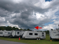
We drove from Charlotte to Wears Valley on Friday. Just east of Asheville, we were in a crazy storm. Had traffic stopped on the interstate because you could not see anything. About 5 minutes later on the radio, we hear the Emergency Alert that a tornado warning has been issued for the area we just came through lol. That was scary.

Then we get to Wears Valley and see this go right overhead. You could see the rotation and everything. It was heading right towards Pigeon Forge and Sevierville. That made my stomach churn a little:

1652187182332.png
 
Here's a really good chart from the Storm Prediction Center describing the severe weather risk levels:

SPC_outlook_final_updated.png
 
~Severe Weather Alert~

There is a Slight risk for strong to severe storms for everyone in East TN with the exception of Southeast TN, which has a Marginal risk, for today.

Timing: Afternoon into the early evening.

Hazards:
- Damaging winds up to 70mph is the primary threat.
- Large hail up to Ping Pong ball size is possible.
-A brief isolated tornado can't be ruled out, but the threat is very low.

VK's thoughts:

While there are areas south of interstate 40 that is in the slight risk, i do think that the biggest threat for severe storms with be along and north of interstate 40.
 
Alert!!!!!!!!!

The National Weather Service in Morristown has issued a

* Severe Thunderstorm Warning for...
Northern Hawkins County in east Tennessee...
Northeastern Hancock County in east Tennessee...

* Until 500 PM EDT.

* At 422 PM EDT, a severe thunderstorm was located over Sneedville,
moving east at 25 mph.

HAZARD...Ping pong ball size hail and 60 mph wind gusts.

SOURCE...Radar indicated.

IMPACT...People and animals outdoors will be injured. Expect hail
damage to roofs, siding, windows, and vehicles. Expect
wind damage to roofs, siding, and trees.

* Locations impacted include...
Rogersville, Sneedville, Surgoinsville, Church Hill, Okolona,
Kepler, Kyles Ford and Klondike.
 

VN Store


Back
Top