East Tennessee Weather II

Well, thanks to the wind, a tree fell on my wife’s car that we’ve had almost a year come Monday. Thankfully she and my son had gotten out of the car and were in the house. When she called and told me, I was expecting the car to be totaled. Just some damage to the door, roof, and hood.
7750DF79-9717-40E6-934E-1216DA7677BF.jpeg
 
Analysis of the winds from this last event. It's wild that we even had a gust to 64 mph at the airport in Knoxville that wasn't even related to a thunderstorm.

 
Well, thanks to the wind, a tree fell on my wife’s car that we’ve had almost a year come Monday. Thankfully she and my son had gotten out of the car and were in the house. When she called and told me, I was expecting the car to be totaled. Just some damage to the door, roof, and hood.
View attachment 443982
That's really not that bad at all. Glad everyone is safe
 
~Severe Weather Alert~

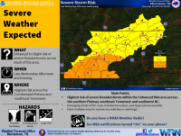
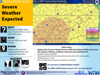
There is an enhanced risk of strong to severe thunderstorms for the plateau, central and southern valley. Slight risk for Northeast TN.

Timing: Late afternoon into the early evening hours.

Hazards:

- The primary threat is damaging winds in excess of 60 mph.

- Large hail to quarter size and a couple isolated tornadoes are possible.
 
Update:

The Storm Prediction Center has downgraded the enhanced risk in the plateau to a slight risk. The central and southern valley are still in the enhanced risk.
 
MRX Discussion:

As of 3PM ET temperatures were warming into the low to mid 70`s
underneath partly cloudy skies. Radar shows a line of showers and
a few thunderstorms developing across middle Tennessee associated
with an approaching front. SW low level flow continues to advect
a moist and increasingly unstable airmass northward this afternoon
with RAP analyzing MLCAPE`s between 500-1000j/kg across the
central/southern valley and plateau areas. The front will continue
to progress east this afternoon with moisture advection
continuing. Expect a gradual increase in storm coverage and
intensity over the next couple of hours as this current activity
moves into a more favorable airmass situated across east
Tennessee. Shear will be more than adequate for updraft
organization as deep layer shear increases to 40-50 knots (higher
north of I-40). Shear vectors oriented just off the boundary will
promote at least some discrete convection and line/bowing segments
into the evening. While damaging winds will continue to be the
main hazard, the threat of tornadoes certainly shouldn`t be
ignored. Shear within the lowest 1km between 15-25 knots along
with favorable LCL heights will maintain the tornado risk through
the evening, especially south of I-40 where better instability
will be located. Additionally, any rotating updrafts will contain
a risk of large hail.
 
Alert!!!!!!

The National Weather Service in Morristown has issued a

* Severe Thunderstorm Warning for...
Southeastern Marion County in east Tennessee...
Southern Hamilton County in east Tennessee...

* Until 645 PM EDT/545 PM CDT/.

* At 600 PM EDT/500 PM CDT/, severe thunderstorms were located along
a line extending from near Signal Mountain to near Bridgeport,
moving east at 40 mph.

HAZARD...60 mph wind gusts and half dollar size hail.

SOURCE...Radar indicated.

IMPACT...Hail damage to vehicles is expected. Expect wind damage
to roofs, siding, and trees.

* Locations impacted include...
Chattanooga, Signal Mountain, Walden, Lakesite, Ridgeside,
Harrison, Fairmount, Red Bank, Collegedale and Lookout Mountain.
 

VN Store


Back
Top