East Tennessee Weather II

Morristown, TN

image1.png


"Significant Snowstorm expected late tonight and Monday morning. Heavy snowfall rates can be expected early Monday morning that will limit visibilities to near zero at times."
 
Is the cold air still going to make it? Looks like is stalled.
It's coming. Going to get some cold air advection, but a lot of what is responsible for the cold air is the dynamic cooling beneath the upper low. That's swinging through over the next couple hours and we'll see temperatures plummet.
 
  • Like
Reactions: norrislakevol
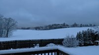
3.5" of dense snow this morning near Strawberry Plains. Had to be some heavy rates because it only snowed about 3 hours. They had 9 inches as of the morning 7am observation at Mt. LeConte.

We had just less that 2 in Jefferson City. Good stuff on this storm!
 
  • Like
Reactions: MetVol
So what’s this system Thursday supposed to bring? Any ideas yet or is it too early?
Just looked at the lunchtime Canadian and Euro models. Both showing snow. Fingers are crossed.

Perhaps, some of the more knowledgeable posters will tell us what they think as we get closer!

I've had a chance to start looking at some of it this evening, and there's some key differences to the most recent one.

First, colder, more seasonable air is going to be in place, but mainly across northern parts of East Tennessee up into SE KY and SW VA. Second, this shortwave trough moving through Thursday night is not as far south, or as strong, as the upper-level trough that moved through last night. This should limit the overall dynamics and snowfall rates. Third, precipitation type and amounts will all depend on the track of the surface low. This track is still very uncertain right now. Model guidance is still all over the place.

Just from my time forecasting around here, we usually have a tough time getting much snow in the valley unless it's a pretty significant shortwave trough that digs pretty far south. If enough cold air and longwave troughing across the east is present, you don't necessarily have to have the former to get some snow, but that's not the case in this situation. This flatter, quick trough would give us a shorter window for precipitation with less upper-level dynamics to support heavy snow. IMO, we'll probably see some light precipitation across the region Thursday night into Friday morning with the best chance of snow across the higher elevations and areas north of I-40, especially up near KY and VA. I just have a hard time buying the ECMWF solution just yet until I see some better consistency.

I will say that I won't be surprised if the GFS shifts to something more like the ECMWF output and snow totals start getting nudged up. The one thing that stands out is that the GEFS plumes show about a 2" mean for snow on Thursday night at TYS compared to the operational run which has nearly nothing. Tells me that the operational run may be an outlier at this time.

The shortwave that will bring us this unsettled weather is forecast to be over the CONUS area by tomorrow evening, so it should be sampled a little better with RAOBs and satellite coverage along the Western CONUS for model ingestion by 0z Wednesday.

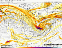
The attached GIF really shows the distinct differences in how each model is handling the shortwave as it moves into the Tennessee Valley 0z Friday. That's the reason for the high uncertainty.

models-2022010312-f084.500hv.conus.gif
 
I've had a chance to start looking at some of it this evening, and there's some key differences to the most recent one.

First, colder, more seasonable air is going to be in place, but mainly across northern parts of East Tennessee up into SE KY and SW VA. Second, this shortwave trough moving through Thursday night is not as far south, or as strong, as the upper-level trough that moved through last night. This should limit the overall dynamics and snowfall rates. Third, precipitation type and amounts will all depend on the track of the surface low. This track is still very uncertain right now. Model guidance is still all over the place.

Just from my time forecasting around here, we usually have a tough time getting much snow in the valley unless it's a pretty significant shortwave trough that digs pretty far south. If enough cold air and longwave troughing across the east is present, you don't necessarily have to have the former to get some snow, but that's not the case in this situation. This flatter, quick trough would give us a shorter window for precipitation with less upper-level dynamics to support heavy snow. IMO, we'll probably see some light precipitation across the region Thursday night into Friday morning with the best chance of snow across the higher elevations and areas north of I-40, especially up near KY and VA. I just have a hard time buying the ECMWF solution just yet until I see some better consistency.

I will say that I won't be surprised if the GFS shifts to something more like the ECMWF output and snow totals start getting nudged up. The one thing that stands out is that the GEFS plumes show about a 2" mean for snow on Thursday night at TYS compared to the operational run which has nearly nothing. Tells me that the operational run may be an outlier at this time.

The shortwave that will bring us this unsettled weather is forecast to be over the CONUS area by tomorrow evening, so it should be sampled a little better with RAOBs and satellite coverage along the Western CONUS for model ingestion by 0z Wednesday.

The attached GIF really shows the distinct differences in how each model is handling the shortwave as it moves into the Tennessee Valley 0z Friday. That's the reason for the high uncertainty.

View attachment 425709
213296BA-762F-4D4B-839B-A58B10412527.gif
 
WBIR and Today Show showing Thursday’s system could begin around lunch time. Looks like East TN could get some good snow again.
 
Good grief. That sure looks like that could be significant if it tracks like they are showing. And, as another poster pointed out, the cold air is already in place so the melting won’t be nearly as severe as this past one.

I'm becoming more confident in some accumulating snow for Thursday. Looks to be a mid-day to evening event. Pretty good amount of cold air ahead of the system this time. Could give us a more widespread 2-4" accumulation. I'll feel more confident after the 0z runs tonight with better observations starting to make their way into the models.

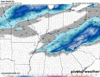
Updated 12z model snow depth for the system:
models-2022010412-f072.snod.us_ov.gif
 
  • Like
Reactions: hUTch2002
I'm becoming more confident in some accumulating snow for Thursday. Looks to be a mid-day to evening event. Pretty good amount of cold air ahead of the system this time. Could give us a more widespread 2-4" accumulation. I'll feel more confident after the 0z runs tonight with better observations starting to make their way into the models.

Updated 12z model snow depth for the system:
View attachment 425859

12z Euro has a weird setup where the central valley gets the bullseye.
 
I’m not as smart as you guys on here but if the low pressure tracks further south does that mean better chance for snow?
It's a happy medium. Need the low far enough south to get moisture and cold air for snow on the north side. Too far north and you get too much warm air, so you get rain and sleet mixing in. Too far south and you run out of moisture. Then you're just left with a cold and cloudy day.
 
  • Like
Reactions: bigdaddy
12z Euro has a weird setup where the central valley gets the bullseye.
Yeah I'm cautious with it. There's several things I could see that bust this one pretty bad that keep me from being too optimistic for a lot of snow right now. Any minor changes in the track of the system will make a big difference, and also could see a shallow warm layer around 4-5k ft result in some sleet that limits accumulation.

Still think snow accumulation is becoming more likely for the entire area, but it's those things that keep my confidence from getting too high just yet.
 

VN Store


Back
Top