ational Weather Service Morristown TN
312 PM EST Sun Jan 14 2018
.SHORT TERM...(Tonight and Monday)...
Broken to overcast midlevel clouds now moving into West TN is
associated with isentropic lift at the 275-285 K level, and will
enter our area tonight. Low levels remain quite dry so no precip is
expected. The main impact will to keep low temps a little above this
morning`s lows, mainly in the upper teens north to low 20s central
and south. These clouds will exit tomorrow morning, with mostly
sunny skies through midday. This along with weak 850 mb warm
advection in a SW flow will bring high temps into the 40s for most
spots. By late afternoon, clouds will be increasing again ahead of
the next system.
.LONG TERM...(Monday night through Saturday)...
Long term forecast continues to be on track for the most part
with a snowy system Tuesday and bitterly cold temperatures through
mid week, followed by a nice warmup for the weekend. Having said
that, adjustments continue to be made for Tuesday and snow totals
have crept up ever so slightly.
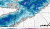
Monday night we are dry as we await the arrival of our cold front
that is associated with a strong area of low pressure across the
Great Lakes Region. Clouds and southwesterly flow will keep temps in
the mid to upper 20s. On Tuesday, a positively tilted and elongated
trough are just back to our northwest with associated cold front
across West TN. Lift still remains plentiful, amount of moisture
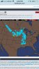
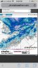
still the biggest question. Again, this will be an all snow event
from start to finish. Models still doing a good job with agreement
on arrival time of precip. It generally looks like the snow will
arrive on the central and northern Cumberland Plateau between 8Z and
12z, then progress into valley locations between 12z and 18z, then
over to northeast TN and our eastern mountains between 18z and 21z.
The NAM and ECMWF continue to be wetter because of the slower
progression of the trough and front, while the GFS is still drier.
Relied heavily on WPC QPF grids for this forecast, which give us
slightly higher snow totals than the previous forecast. Amounts
still aren`t overly impressive but it does look like enough snow
will fall to cause travel issues during the day. As of now, 0.5
inches to 1 inch possible across the southern TN Valley up to I-40,
1 to 1.5 inches possible from I-40 north up through northeast TN.
Portions of southwest VA could see 1 to 2 inches and our highest
terrain areas will see 2 to 3 inches. Southwest NC should see the
lightest amounts with around half an inch expected in the lower
elevations and up to 1 inch across the highest terrain.
Snow gradually tapers off Tuesday evening but will linger during the
overnight areas for areas mainly east of I-40. Lows will be in the
single digits so whatever snow has accumulated by sunset will not
melt overnight. A few flurries still possible early Wednesday
morning across our eastern mountains before the trough pushes
further east during the day. Highs on Wednesday still the coldest of
the period with highs in the low to mid 20s, which is 20 to 25
degrees below normal. The highs will be colder than our normal lows
for this time of year. Some slick spots still possible early
Wednesday morning.
For the rest of the period we moderate our temperatures as ridging
builds across the region. This weekend we are back into the low to
mid 50s. Our next chance of rain comes late on Sunday as another
trough and low pressure swing through the area.
&&