East Tennessee Weather II

Here is question for you guys..what causes this dry puffy snow to basically evaporate? I was watching it today on the deck and it wasn't melting, it was just kind of disappearing.
 
My thoughts as of now:

Valley: 1-2 inches
Plateau: 1-3 inches
Mountains: 2-4 inches

Locally higher amounts possible in the higher elevations.
 
Phone froze. Here it is VK I uploaded the wrong one. Looks pretty amped. Slowing down is key for a moisture tap
 

Attachments

  • 258DF60C-D4E4-4003-B397-F087DFBB9FA5.jpg
    258DF60C-D4E4-4003-B397-F087DFBB9FA5.jpg
    83.6 KB · Views: 7
High ratio. 17-22-1
 

Attachments

  • D9A0EE7E-D370-4D13-B5EC-01645711949D.jpg
    D9A0EE7E-D370-4D13-B5EC-01645711949D.jpg
    93.9 KB · Views: 5
  • 105667BA-BC79-42DB-8D4B-3FF81D94187E.jpg
    105667BA-BC79-42DB-8D4B-3FF81D94187E.jpg
    66.6 KB · Views: 1
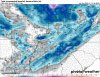
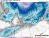
I'm playing around with this Pivotal Weather a little bit. It's neat! I'm still very much a novice as far as knowing which models are more reliable in different time frames.

Gah, I'm getting excited!

My opinion

GFS & EURO for long casting
Then GEM for 72 hours
Then NAM for 20-48hours
Then HRRR for now casting

Also look at Wator vapor maps, Temps, Ratio’s and odds and ins.
 
So, if I'm looking at a map that says 12Z, does that mean it would be 6AM our time? What I read seemed to indicate this was based on the Greenwich time. I may have misread, but I wanted to ask because I knew one of you guys would know.
 

VN Store


Back
Top