East Tennessee Weather II

Been at work all day, inform me

See attached. One is Kuchera ratio, and the other is basic 10:1.

Edit: I’ll clean up and attach better pictures shortly.
 

Attachments

  • D3C5EB0C-4680-408C-8A03-270741D19C9D.jpg
    D3C5EB0C-4680-408C-8A03-270741D19C9D.jpg
    39.6 KB · Views: 4
  • 82FF60DF-0F21-45B0-9747-FBF80111B6CF.jpg
    82FF60DF-0F21-45B0-9747-FBF80111B6CF.jpg
    38.8 KB · Views: 3
See below. This is the 18z NAM.
 

Attachments

  • 8AA6CBFA-9ED1-4001-895B-AFF8F25C0FD8.jpg
    8AA6CBFA-9ED1-4001-895B-AFF8F25C0FD8.jpg
    72 KB · Views: 0
  • 2D8935BA-E944-45CA-9BA4-85610DC3C9C6.jpg
    2D8935BA-E944-45CA-9BA4-85610DC3C9C6.jpg
    60.4 KB · Views: 2
Last edited:
My prediction is some light dusting snow tonight after rain and more rain on Sunday
 
I'm not an expert by any means, but it sure does look like we are gonna get some snow tonight based on the radar and forecasts I've read.
 
WWA for the valley
Winter Weather Advisory
URGENT - WINTER WEATHER MESSAGE
National Weather Service Morristown TN
234 PM EST Thu Feb 1 2018

...SNOW THIS EVENING THROUGH EARLY FRIDAY MORNING ACROSS
SOUTHWEST VA, NORTHEAST AND CENTRAL TN VALLEY, PLATEAU, AND THE
EAST TN MOUNTAINS...

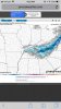
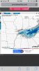
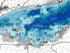
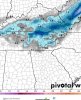
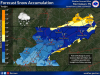
.Rain will spread across the Southern Appalachian Region today as
a cold front moves into the area. Colder air will move in behind
the front allowing the rain to transition to snow this evening.
Accumulating snow of 2 to 4 inches can be expected across
southwest virginia and far east Tennessee mountains and 1 to 2
inches over the northern Plateau and northeast and central
Tennessee Valley.

TNZ036>040-067>071-073-020345-
/O.EXB.KMRX.WW.Y.0006.180202T0200Z-180202T0900Z/
Anderson-Union-Grainger-Hamblen-Northwest Cocke-Roane-Loudon-Knox-
Jefferson-NW Blount-North Sevier-
Including the cities of Clinton, Oak Ridge, Maynardville,
Rutledge, Morristown, Newport, Kingston, Lenoir City, Knoxville,
Dandridge, Maryville, and Sevierville
234 PM EST Thu Feb 1 2018

...WINTER WEATHER ADVISORY IN EFFECT FROM 9 PM THIS EVENING TO
4 AM EST FRIDAY...

* WHAT...Snow accumulations. Total snow accumulations of 1 to
possibly 2 inches are expected.

* WHERE...Central Tennessee Valley, including Knoxville and
Morristown.

* WHEN...From 9 PM this evening to 4 AM EST Friday.

* ADDITIONAL DETAILS...Be prepared for slick roads and reduced
visibilities at times.

PRECAUTIONARY/PREPAREDNESS ACTIONS...

A Winter Weather Advisory for snow means periods of snow will
cause primarily travel difficulties. Be prepared for snow covered
roads and limited visibilities, and use caution while driving.
The latest road conditions for the state you are calling from can
be obtained by calling 5 1 1.
 
The following pretty much reflects my thoughts on snow accumulation. I would lean towards the 2 inches in the valley to be on higher elevated areas such as ridges.

27356275_10155738686777655_5230201176817608614_o.jpg
 
Is that a "trace" to 2"?

That's terrible reporting. That's like saying "I really don't know how much snow is going to fall in the valley."
 
Last edited:
  • Like
Reactions: 1 person
Moisture is dissipating. This isn't going to amount to anything. Maybe a dusting in places. Black ice in the morning is possible.
 
Down to 36 @ the house in Farragut. Seems to be getting colder than expected...
 
Down to 36 @ the house in Farragut. Seems to be getting colder than expected...

38 here at Lovell and Psippi. Had some graupel earlier, seeing snow and rain mixed. Nothing sticking obviously.

On radar it looks like the moisture is pushing south pretty fast. Might not have any moisture by 1am I'd guess.
 
Last edited:

VN Store


Back
Top