Vol knight
Text a Buddy!
- Joined
- Oct 2, 2013
- Messages
- 8,958
- Likes
- 3,141
Sad to see temperatures are going to rise back up limiting a chance for snow in Knoxville for the next 15 days or so, according to the Weather Channel.
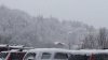
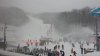
I will say, last Wednesday was awesome.
@ Christmas time, with record rainfall, surrounded by 3 record highs, some of you thought "winter is over."
I responded, "be patient."
But now, the pattern has changed. We may get some warm days, but they are not likely to last. In fact, some of the best snows in this pattern will sneak up on you...with just a few days notice.
~Severe Weather Bulletin~
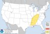
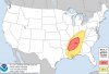
This bulletin is mainly for those in Middle and West Tennessee, but folks in East Tennessee do need to keep an eye on this upcoming system. There's a strong shortwave trough that will move into the area on Tuesday, which will bring a chance for Strong to Severe Thunderstorms. There's still quite a bit of time until the event, so we will have to keep an eye on it.
")