Orange_Vol1321
Well-Known Member
- Joined
- Dec 4, 2012
- Messages
- 28,177
- Likes
- 42,258
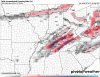
I sure hope the canadian model is wrong next Friday/Saturday. Showing bad ice. The GFS shows it slightly warmer here and the ice being further North in KY.
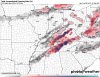
It's about time to start following the the upcoming system on Sunday. Not for Snow, but for freezing rain and sleet. This is just one model, but here's the 18z GFS run for total ice accretion Sunday into Monday.
What about the valley? Is there a model for us?

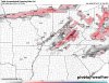
I'm expecting this to primarily be a rain maker of a system for most of East Tennessee. Temperatures will be warming up big time throughout the day today and through the overnight. Some places could get close to 70 tonight. Once we get close to sunrise tomorrow, temperatures will be rapidly falling throughout the day. In a period of 3-6 hours, we could see a 20-30 degree drop in temps. The ice threat will remain in the Plateau and points west, with ice accretion Sunday ranging from 0.1 to 0.5 of an inch. On the back end of the system on Sunday, we could see a brief transition to flurries or snow showers before it tapers off. No snow accumulation is expected in the valley, with only minor accumulations (dusting) in the higher elevations.
Generally is the Canadian or the GFS more accurate during the winter? Or is it hit and miss? Thanks for the postings, btw.
Good thing that WATE still doesn't do the 6 degree guarantee..colder air got trapped in the valley and instead of low 60s...I don't think we made it over 45 today...no white Christmas for ET this year...of course I'll be in Florida and its supposed to be 80 something every day there

") I'm ready for some spring time weather all ready
I'm ready for some spring time weather all ready