East Tennessee Weather

Status
Not open for further replies.
Amazing it looks like the first wave might go just north and the 2nd wave could go just south...if both don't shift from the models I've seen, the valley could get shut out.

Huh? You not see the gfs shift? Or the NAM that just came out. This is the first wave.
 

Attachments

  • imageproxy.jpg
    imageproxy.jpg
    119.3 KB · Views: 9
I've seen a few people say knoxville will get shut out, and a few say we're in for a surprise lol. I guess we'll see on Friday

Neither would surprise me..its that close. I have to drive to Gulf Shores so I'll miss out either way :)
 
Todd Howell raised his first snow totals to a little over an inch for the valley...there just isn't much energy with that one...didn't say for the 2nd
 
Last edited:
Todd Howell raised his first snow totals to a little over an inch for the valley...there just isn't much energy with that one...didn't say for the 2nd

I think it's basically a piece of the main storm that has broke away coming as the first wave. The NAM just came out in the last hour so what he went by at 6pm was an earlier model. Right now we're in it's wheelhouse and it a short-range model. If that happens like the model is showing it will be peppering the snow late tomorrow night / early friday morning.

Never know even looking at models within even 24 hrs but thats what makes weather intriguing.

Which way you taking to Gulf Shores and when are you leaving?
 
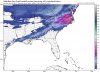
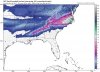
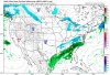
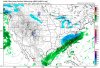
i think it's basically a piece of the main storm that has broke away coming as the first wave. The nam just came out in the last hour so what he went by at 6pm was an earlier model. Right now we're in it's wheelhouse and it a short-range model. If that happens like the model is showing it will be peppering the snow late tomorrow night / early friday morning.

Never know even looking at models within even 24 hrs but thats what makes weather intriguing.

Which way you taking to gulf shores and when are you leaving?
75/24/59/459/65 winter store watch around Gadsden to Birmingham I can leave anytime after my class on Friday, which gets out at 1pm...wife and son stayed down at Christmas to help out after her dad had surgery.
 
Last edited:
0z GFS shows first wave further north

gfs_mslp_pcpn_frzn_us_4.png
 
0z GFS was not good for Knoxville and areas west. 0z RGEM and NAM were decent. Now to see what the 0z UKMET, CMC, and Euro say.
 
Aldrich from channel 8 says .5-2" for Knoxville and 2-5+ for the mountains. Todd Howell says about the same for Knoxville and 3-6+ for the mountains if I'm remembering those correctly.

All I know is I hope it snows butthole deep to a 9 ft Indian. I'd be alright with that.
 
0z UKMET was good. Canadian was decent. Euro was ouch!

With all of tonight's model runs done, I'm ready to give my thoughts. The southern valley (Monroe and Mcminn counties and areas southwest) will probably only see a dusting. Central Valley and Northern Plateau will see 1-2 inches. Northeast TN and the Smokies will see 2-4 inches with some higher elevated areas seeing 5 inches.
 
For the second system. Areas from Knoxville south &a East will see a higher total. Barring any changes. With the 6Z model runs there was again a slight shift north and west. The blocking High over Canada is weaking with each run and some models are indiciting a high forming over the pacific now which could push it farther North and West and slow it down. 12 Z runs will be the ones to watch.
 
Last edited:
.

That's the 10:1 ratio. I'm going with the 15:1 ratio.

We will see snow.
 

Attachments

  • IMG_1113.jpg
    IMG_1113.jpg
    68.3 KB · Views: 8
  • IMG_1112.jpg
    IMG_1112.jpg
    70.8 KB · Views: 5
  • IMG_1111.jpg
    IMG_1111.jpg
    72.4 KB · Views: 5
  • IMG_1110.jpg
    IMG_1110.jpg
    66.6 KB · Views: 8
06z RGEM looking the same.
 

Attachments

  • rgem_mslp_pcpn_frzn_seus_16.thumb.png.5ca86791affd592dc9c3395c748fd732.jpg
    rgem_mslp_pcpn_frzn_seus_16.thumb.png.5ca86791affd592dc9c3395c748fd732.jpg
    102.9 KB · Views: 3
Models aren't picking up on the moisture available during the first wave. The cold air will squeeze every drop out.
 
12z NAM NW cut looking even better. Hour 36.
 

Attachments

  • refcmp_ptype_conus.thumb.png.89cf5fbe928d69d24334bdf8a3403615.jpg
    refcmp_ptype_conus.thumb.png.89cf5fbe928d69d24334bdf8a3403615.jpg
    105 KB · Views: 3
Last edited:
And look at hour 42 of the NAM, the backside spin looking great.
 

Attachments

  • namconus_ref_frzn_us_38.thumb.png.4687955e55d29d02b17aacc5c4edee62.jpg
    namconus_ref_frzn_us_38.thumb.png.4687955e55d29d02b17aacc5c4edee62.jpg
    109.7 KB · Views: 4
Status
Not open for further replies.

VN Store


Back
Top