East Tennessee Weather

Status
Not open for further replies.
I can't really check but anyone care to see the model run of the new NAM at 72 hours and compare it to the latest GFS. Follow the track of the low and see the intensity and also follow the High pressure
 
I can't really check but anyone care to see the model run of the new NAM at 72 hours and compare it to the latest GFS. Follow the track of the low and see the intensity and also follow the High pressure

Looks like the models are lining up for a southern track.

nam_mslp_pcpn_frzn_us_24.png


gfs_mslp_pcpn_frzn_us_12.png
 
Last edited:
I think most of ET will at least get to see some snow this weekend..here is the best chance...Friday morning-afternoon

nam_mslp_pcpn_us_13.png
 
Looks like WVLT is backing off the snow forecast on Saturday


Good Morning! We start your morning mild, but temperatures are starting to get cold as we get into the rest of the week. Clouds turn into sunshine this afternoon with temperatures sitting in the 40s for most of our day.
Tonight turns cloudy, as temperatures start to drop fast. You want to start throwing on the heavier layers tomorrow morning as temperatures drop to the 20s as we start your day. We reach 43 degrees for your high on Thursday.
We expect to see flurries late Thursday night with a 60% chance for light snow on Friday. Light to moderate accumulation is possible. You will want to pull out the jackets, scarves and gloves for Friday because we only hit a high of 35 degrees.
That will take us into a bitter cold weekend. We expect to see sunny skies with highs in the low 30s for the whole weekend.
Let's make today great!
Dani Ruberti
Local 8 Weather
 
12z GFS low still tracking south of Tennessee..this could be a major snow event for North Georgia and parts of North Carolina
gfs_asnow_us_19.png
 
Not that this will be a blizzard, but they had all sorts of trouble forecasting the events leading up to the blizzard of '93. It wasn't until like 6 hours before the storm hit that they had any idea of what was going to happen. Every station went back and forth between it being a rain event to slight snow to rain.
 
Curious to see what they say at 12...ground temps are still really warm...50 degrees

TENNESSEE FARMERS COOPERATIVE

Its down in the 30's now in West TN behind that cold front that pushed through overnight. If the low decides to track a 100 miles farther north West, Middle, and East Tn will see a lot of snow with north Georgia seeing mix

Should be interesting the next few days
 
  • Like
Reactions: 1 person
WVLT models "anywhere from an 1 inch to 5 inches in valley" will know more by Friday
WBIR snow to start after 10pm Thursday 1-2 inches more north less south less than inch in valley..2nd system EURO is more snow friendly other models keep it south..lots of uncertainties right now best guess 1/2-1 inch north more south and east
 
Its down in the 30's now in West TN behind that cold front that pushed through overnight. If the low decides to track a 100 miles farther north West, Middle, and East Tn will see a lot of snow with north Georgia seeing mix

Should be interesting the next few days

I think it will definitely be cold enough to snow...I just wonder how much will lay..first system doesn't have a ton of moisture so anything that doesn't stick right away will limit totals.
 
WBIR said that the EURO is the most snow friendly for the 2nd system..the other 4-5 models keep the snow south and east of ET
 
Quick thoughts .

We will use the 15:1 ratio due to the cold air.

With cold air being in place I see a more intensified storm that the models haven't picked up on yet. I think it'll track more north. Just my thinking. We will see. Most models use the 10:1 ratio just a FYI. So where we see one inch it could be more. I'll post my thoughts later tonight.
 
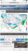
Looks like the confidence for snow is falling at the NWS All the special weather statements for ET have expired...strange I thought we might get at least an advisory the 1st event. This is the alert for Nashville

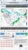
...The First Snowfall of the Season is Possible Thursday
Afternoon through Friday Night...

As cold temperatures settle into the region late this week, Middle
Tennessee will have its first opportunity for accumulating
snowfall.

Starting Thursday afternoon and ending Friday night, the
Cumberland Plateau is likely to see the majority of any snowfall
we experience. Snowfall totals of an inch or slightly more are
possible through this time frame. Everyone else across Middle
Tennessee is more likely to see a dusting to one inch of snow.

While snowfall totals are not expected to be excessive by any
stretch, any amount of snow will cause at least minor travel
impacts across the mid-state. However, with higher totals on the
Cumberland Plateau, moderate travel impacts could be experienced
both Friday and Saturday mornings.
 
Last edited:
spoke too soon we have a WWA

Winter Weather Advisory
URGENT - WINTER WEATHER MESSAGE
NATIONAL WEATHER SERVICE MORRISTOWN TN
311 PM EST WED JAN 4 2017

...LIGHT SNOW ACCUMULATIONS EXPECTED FROM LATE THURSDAY AFTERNOON
THROUGH FRIDAY MORNING...

.A FAST MOVING ARCTIC FRONT WILL PUSH ACROSS THE SOUTHERN
APPALACHIAN REGION LATE THURSDAY AFTERNOON THROUGH FRIDAY MORNING.
A SURGE OF COLDER AIR WILL QUICKLY CHANGE LIGHT RAIN TO SNOW ACROSS
THE REGION BY LATE AFTERNOON INTO THE EVENING HOURS. THESE BROAD AREAS
OF SNOW WILL CONTINUE TO SPREAD ACROSS THE AREA OVERNIGHT. SNOWFALL
ACCUMULATIONS WILL BE GREATEST ALONG THE NORTHERN PLATEAU OF EAST
TENNESSEE AND THE CUMBERLAND MOUNTAINS OF SOUTHWEST VIRGINIA WHERE
1 TO 3 INCHES ARE POSSIBLE. ELSEWHERE...GENERALLY AROUND 1 INCH OF
SNOW IS EXPECTED ACROSS VALLEY LOCATIONS...BEFORE IT TAPERS OFF
AROUND SUNRISE FRIDAY MORNING.

THE SUBFREEZING SURFACE TEMPERATURES WILL ALLOW ANY SNOW THAT FALLS
TO ACCUMULATE ON UNTREATED ROADS. THIS WILL RESULT IN NEGATIVE
TRAVEL IMPACTS TO MOTORISTS...ESPECIALLY DURING THE FRIDAY MORNING
RUSH HOUR COMMUTE.

TNZ016>018-036>047-067>074-086-087-VAZ006-008-051000-
/O.NEW.KMRX.WW.Y.0001.170106T0000Z-170106T1200Z/
HAWKINS-SULLIVAN-JOHNSON-ANDERSON-UNION-GRAINGER-HAMBLEN-
NORTHWEST COCKE-COCKE SMOKY MOUNTAINS-NORTHWEST GREENE-
SOUTHEAST GREENE-WASHINGTON TN-UNICOI-NORTHWEST CARTER-
SOUTHEAST CARTER-ROANE-LOUDON-KNOX-JEFFERSON-NW BLOUNT-
BLOUNT SMOKY MOUNTAINS-NORTH SEVIER-SEVIER SMOKY MOUNTAINS-
NORTHWEST MONROE-SOUTHEAST MONROE-RUSSELL-WASHINGTON-
INCLUDING THE CITIES OF...ROGERSVILLE...KINGSPORT...BRISTOL...
MOUNTAIN CITY...CLINTON...OAK RIDGE...MAYNARDVILLE...RUTLEDGE...
MORRISTOWN...NEWPORT...COSBY...GREENEVILLE...CEDAR CREEK...
JOHNSON CITY...ERWIN...ELIZABETHTON...ROAN MOUNTAIN...KINGSTON...
LENOIR CITY...KNOXVILLE...DANDRIDGE...MARYVILLE...CADES COVE...
SEVIERVILLE...GATLINBURG...MADISONVILLE...COKER CREEK...LEBANON...
ABINGDON
311 PM EST WED JAN 4 2017

...WINTER WEATHER ADVISORY IN EFFECT FROM 7 PM THURSDAY TO 7 AM
EST FRIDAY...

THE NATIONAL WEATHER SERVICE IN MORRISTOWN HAS ISSUED A WINTER
WEATHER ADVISORY FOR LIGHT SNOW...WHICH IS IN EFFECT FROM 7 PM
THURSDAY TO 7 AM EST FRIDAY.

* EVENT...SNOWFALL ACCUMULATIONS AROUND 1 INCH...WITH A FEW
LOCALLY HIGHER AMOUNTS.

* TIMING...THURSDAY EVENING THROUGH EARLY FRIDAY MORNING.

* IMPACTS...TRAVEL WILL LIKELY BECOME HAZARDOUS ONCE THE WINTRY
PRECIPITATION BEGINS. MOTORISTS NEED TO BE ESPECIALLY CAREFUL
ON BRIDGES AND OVERPASSES WHERE SLIPPERY SPOTS OFTEN DEVELOP
FIRST.

PRECAUTIONARY/PREPAREDNESS ACTIONS...

A WINTER WEATHER ADVISORY FOR SNOW MEANS THAT PERIODS OF SNOW ARE
EXPECTED OR OCCURRING...WHICH WILL PRIMARILY CAUSE TRAVEL
DIFFICULTIES. BE PREPARED FOR SNOW COVERED ROADS AND LIMITED
VISIBILITIES...AND USE CAUTION WHILE DRIVING.
 
Status
Not open for further replies.

VN Store


Back
Top