East Tennessee Weather

Status
Not open for further replies.
~Severe Weather Alert~

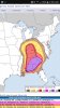
There's a Slight risk for Strong to Severe thunderstorms on Wednesday for all of East TN. This risk is conditional due to a few uncertainties in the forecast.

1. The track of the low. Currently, it is set to track from the Mississippi River Valley to the Great Lakes. Any change to this could strengthen or weaken the storms.

2. Convection possible south of us. If there is a good amount of storms firing up south of us towards the Gulf, they could cut off some of the moisture to our area, thus lessening our severe threat.

3. Timing of the system.

That said, there's a possibility we could see some supercells on Wednesday, which means large hail, damaging winds, and even tornadoes are on the table. I'll continue to monitor this system and give updates.
 
Idk how much longer I'll be posting on VN.. You literally cannot post anything and expect not to get bashed. (Tough skin) I know but 7,000 post in and it's starting to get to me.

You need me to go rough somebody up for you? Just say the word. :)
 
  • Like
Reactions: 2 people
Update:

Everyone in East Tennessee is now in an Enhanced Risk for Severe thunderstorms on Wednesday afternoon and evening. It's getting to the point where we may see an Outbreak of severe weather.

We are also included in the hatched area according to the NWS SPC. For those who don't know what the hatched area is, it's an area where the NWS highlights at least a 10% probability of seeing significant severe weather.

As always, I'll continue to monitor the system and give you updates, and so will RT.
 

Attachments

  • Screenshot_20170404-020807.jpg
    Screenshot_20170404-020807.jpg
    88.4 KB · Views: 3
  • Like
Reactions: 1 person
Sheesh! A good portion of Alabama and the majority of the state of Georgia are going to have a bad day.
 
😮😮😮

hio/Tennessee Valleys...
Confidence is increasing in warm sector moisture return that will
become supportive of weak to moderate CAPE, within at least a narrow
pre-frontal plume overspreading the region from west to east
Wednesday afternoon and evening. Aided by forcing within the exit
region of a 70-90 kt cyclonic 500 mb jet, and strengthening of
southerly 850 mb flow to 30-50 kt within the warm sector, the
environment is expected to become conducive to discrete supercell
storm development, at least initially. This is expected to be
accompanied by a risk for large hail and a few tornadoes, some of
which could be strong. Eventually, large-scale forcing may support
upscale growing lines or clusters of storms accompanied by a more
substantive risk for damaging wind gusts.
 
Some of the wording that I've read from the SPC and the ATL and Birmingham NWS offices is concerning. One of the quotes was "outbreak of destructive long track tornadoes"

The last time that I saw wording this similar was April 2011.
 
Some of the wording that I've read from the SPC and the ATL and Birmingham NWS offices is concerning. One of the quotes was "outbreak of destructive long track tornadoes"

The last time that I saw wording this similar was April 2011.

Can you paste in the link?
 
given the forecast coverage of convection, it is not out of the question that higher severe probabilities may need to be considered in a later outlook update.- For the Tn Valley
 
Morristown is definitely taking a conservative stance with this system. We're really not going to know how bad the storms will be until we see if the first wave hits us head on, or if it grazes us and mainly stays to the south. If the latter happens, then it could get brutal tomorrow afternoon. If the former happens, then it won't be as bad.
 
Status
Not open for further replies.

VN Store


Back
Top