WallyBalls
Atom Wrangler
- Joined
- Aug 15, 2010
- Messages
- 7,183
- Likes
- 4,458
http://forecast.weather.gov/product...MX&product=AFD&format=CI&version=1&glossary=1
NWS Birmingham forecast discussion
Aldrich's 11pm forecast didn't have storms coming in until around 7pm. The futurecast he showed didn't look too impressive but those are to be taken with a grain of salt.
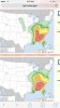
Just as I thought, a Moderate Risk was going to be expanded to middle TN and the plateau. Also, the Enhanced risk has shifted west some to the point that areas east of Knox County have been downgraded to Slight. What I've been seeing in the past few model runs is a westward trend where the worst is setting up from the plateau and points west.
Having said that, I expect more changes to come in the outlooks, whether that be an increased risk for Severe thunderstorms or a decreased risk. Other than the first wave of rain, we need to see how much cloud cover do we see before the storms arrive. Cloud cover doesn't stabilize the air mass, but it can inhibit the growth of instability. More sun equals worse storms.
DAY ONE...Today and Tonight
...Outbreak of Severe Thunderstorms Expected Across the Eastern
Tennessee Valley and Southern Appalachian Region This Afternoon
and Evening...
A strong upper-level storm system will move into the region
on today. The associated cold front is expected to trigger
scattered to numerous severe thunderstorms during the afternoon
into the evening. Damaging straight-line winds in excess of 60 mph
and hail up to the size of baseballs will be possible with these
storms.
A few tornadoes will also be possible with the strongest
storms. Additionally, a localized strong tornado cannot be ruled
out, particularly along the Cumberland Plateau and across
southeast Tennessee.
I'll say this ahead of time:
If you have a vehicle that you love and don't want to be damaged by hail up to baseball size (yes, we have a chance to see very large hail), I'd recommend keeping them in a garage or putting under a covered area.