So what should I expect here in West TN/Memphis/Tipton County area? My mom has her chemo treatment in Jackson tomorrow so we're hoping she can go.
Posted 29 minutes ago
...WINTER WEATHER WILL AFFECT THE MID-SOUTH LATE THIS EVENING
INTO FRIDAY...
.A strong cold front will move into the Lower Mississippi Valley
late this evening. Rain will begin to transition to a mixture of
freezing rain and sleet as cold air begins to filter into the Mid-
South, then eventually to all snow on Friday. Snow is expected
to taper off Friday afternoon. Significant snow and ice
accumulations will be possible across much of the region. In
addition, strong northwest winds will occur as the much colder
air filters into the region.
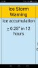
...WINTER STORM WARNING REMAINS IN EFFECT FROM MIDNIGHT TONIGHT
TO 6 PM CST FRIDAY...
* WHAT...Heavy mixed precipitation expected. Plan on difficult
travel conditions, including during the morning commute on
Friday. Total snow and sleet accumulations between one and three
inches and ice accumulations of around one tenth of an inch are
expected. The greatest snow and sleet accumulations are
expected across northwest Tennessee.
* WHERE...Portions of East Arkansas, North Mississippi,
Southeast Missouri and West Tennessee.
* WHEN...Midnight to 6 PM Friday.
* ADDITIONAL DETAILS...Be prepared for significant reductions in
visibility at times.
PRECAUTIONARY/PREPAREDNESS ACTIONS...
A Winter Storm Warning means significant amounts of snow, sleet
and ice are expected. This will make travel very hazardous or
impossible. The latest road conditions for the state you are
calling from can be obtained by calling 5 1 1.
Tweets related to this alert
WBBJ7News
@WBBJ7News 12m
Milan Special School District closed Friday #tnwx
The News Courier
@newscourier 14m
Officials with Calhoun Community College have announced the school will be closed Friday because of the threat of... fb.me/WpgWzxEL
The Messenger
@MessengerOnline 15m
SCHOOLS CLOSED FRIDAY. From Hopkins County Schools: With freezing rain, sleet and snow expected to fall... fb.me/9qJU6yC6A
Tom Meiners
@WBBJ7TomMeiners 19m
6:30pm THURSDAY, JANUARY 11th, 2018 A Winter Storm Warning has been issued for most of West Tennessee from tonight
twitter.com/i/web/status/9
FRA Panthers
@FRApanthers 44m
Due to the threat of icy weather and potentially-hazardous road conditions, school is canceled for tomorrow,... fb.me/LryL6hpx
WilliamsonA.M.
@WilliamsonAM 45m
Williamson County Schools, Franklin Special School District to close Friday as county braces for winter storm tnne.ws/2EwXsSH
WMC Action News 5
@WMCActionNews5 48m
Winter Storm Warning issued for parts of the Mid-South #wmc5 >>buff.ly/2Dld3FB pic.twitter.com/BAaS6E9SL7
Show image
FRA Panthers
@FRApanthers 51m
Due to the threat of icy weather and potentially-hazardous road conditions, school has been canceled for tomorrow,
twitter.com/i/web/status/9
Metro Schools
@MetroSchools 3h
MNPS will close all schools tmrw, Fri, Jan. 12, 2018 for inclement weather. No after school programs. No before/aft
twitter.com/i/web/status/9
WCS
@WCSedu 3h
BREAKING NEWS: Williamson County Schools will be CLOSED Friday, January 12, 2018 due to the threat of freezing rain
twitter.com/i/web/status/9
Show more
Related News
Winter Storm Hunter to Bring Snow, Ice From Tennessee and Arkansas to Northern New England
The Weather Channel · 1 hour ago
Snow and a narrow zone of freezing rain and sleet are currently impacting an area from Missouri and Illinois into Wisconsin and the Upper Peninsula of Michigan.
4WARN Weather Alert: Winter storm moving toward Middle TN ...
WSMV Nashville · 10 hours ago
A 4WARN Weather Alert has been issued for Friday because of the possibility of snow and ice in Middle Tennessee.
Winter weather: TDOT prepped and ready for ice and snow to hit ...
The Tennessean · 8 hours ago
In preparation for the winter season, salt supplies have been replenished in all 95 counties, and crews have readied snow plows and brine trucks.
MORE
ready.govWays to prepare and stay safe now
During
Stay indoors during the storm.
Prolonged exposure to cold can cause hypothermia.
Walk and drive carefully on icy sidewalks and roads.
Many injuries and accidents are caused by slippery conditions.
Before driving, let someone know your destination, route, and expected time of arrival.
If your car gets stuck, itll be easier to find you.
If you lose feeling and color in your nose, ears, hands, or feet, cover the exposed area, avoid rubbing your skin, and seek medical help immediately.
You may have frostbite.
When shoveling snow, take breaks and lift lighter loads.
Working too hard can lead to heart attacks.
Stay dry.
Wet clothes make you lose body heat, increasing your risk of hypothermia.
noaa.govWhat is a Winter Storm Warning?
Warning
Watch
A winter weather event including 1) snow, ice, or sleet meeting or exceeding locally defined 12 and/or 24 hour warning criteria; or 2) a combination of snow, ice, or sleet and blowing snow with at least one of the precipitation elements meeting or exceeding locally defined 12 and/or 24 hour warning criteria.
Privacy Help and FAQ Terms of use Flag as i