East Tennessee Weather II

Definitely keeping an eye on Saturday for our area. Usually, when the SPC is highlighting a severe threat 6+ days out, there's a good chance for a severe weather outbreak.

Indeed. There will be plenty of dynamics and shear with the system this weekend. Will be interesting to see how powerful the shortwave coming out of the desert southwest is. GFS has it winding up pretty good, producing at least some super cells and multiple rounds of line segments which could contain QLCS (Quasi Linear Convective System) vorticities. Check out the simulated radar on the latest model run if you want. So, it looks like there may be (still a long ways out) a tornado threat, and damaging wind threat, and perhaps a large hail threat too. I would imagine that lapse rates would be steep. Latest run has a very serious threat along the warm front it looks like setting up in northern Tennessee and southern KY. Along the warm front is often where we see the biggest tornado out breaks since that is where the greatest shear is. Where ever that sets up is where it will be very dicey. Long ways to go. The greatest threat for most will likely be heavy rainfall. Two model runs in a row have dumped 6 to 10 inches of rain on east Tennessee through Monday morning. That's a ton of rain. If the GFS is correct then the Plateau, Mountains, and perhaps the northern valley could see some snowfall accumulation with wrap around moisture on Monday once the low pressure system ejects to our north and east. Some places could go from severe thunderstorms to accumulating snow in a matter of hours. A fascinating scenario.

Don't sleep on the possibility of severe weather on Wednesday either. Most of it will be to our south, be there will be at least a small threat in the southern valley and southern plateau in particular, as well.
 
Todd Howell (WBIR) just showed a map of Sunday at 1:00pm with heavy rain in East TN and snow in West TN. He wouldn’t go any further than that time.
 
Spann is right. Long range models 6-7 days out are very poor at details. They can do a reasonable job at detailing the pattern, but the details are difficult to get even a couple days in advance. Sometimes just a slight change in the track or strength of a system can have major effects on the severe weather or winter weather that occurs.

That being said, I'd say my main concern with the rest of this week into the weekend is heavy rainfall rates and periods of flash flooding. It looks like we're going to have a boundary across the area with strong low-level convergence really enhancing precipitation and potential training convection. Moisture values are at a maximum for the climatological record, so we're in uncharted territory. Things can, and will, change between now and then, but the heavy rainfall would be what I'm most concerned about.

There's a risk of severe weather Wednesday evening with an even better chance on Saturday. However, in each case, it's conditional on how much instability we have. Could get quite a bit of severe weather or it could be a bust. I could see each scenario play out and wouldn't be surprised by it. If severe weather manages to occur Saturday, it could be significant.

I could easily see some mountain snow in this scenario on Sunday and Sunday night as a secondary low pressure system develops across the Carolinas with moisture feeding back into the cold air and upslope NW flow enhancing lift across the terrain.

snod.us_state_ky_tn.png


What I'm about to say is not necessarily about this event but about getting warnings in general. What I encourage people to do is always have multiple ways to get warnings. Have redundancy. I've seen WEA (wireless emergency alerts) fail, and even when it works, some setting on a phone prevents it from working right. Weather radios are great as well, but sometimes they have issues with signal reception depending on your proximity to a transmitter. WEA and weather radios are both great ways to get warnings, but you need to have redundant methods to get warnings for life threatening hazardous weather.
 
Saturday is really starting to get my attention as well. A lot can still change between now and then, but it looks like we're going to be in a situation where if we get some sunshine and warmth during the afternoon hours, we're going to be primed for severe weather, including some tornadoes around southern East and Middle Tennessee. The current timing for the front is to move through Saturday evening between 6pm and midnight which is near the perfect diurnal time for some severe weather potential. It's something to keep a close eye on.

1640795886463.png
 
Check out ( Ryan Hall Y’all ) on Twitter and his upcoming up to the minute livestream of today’s storms on YouTube, same handle across social media. This meteorologist was pinpoint accurate with the early Dec super tornadoes and was telling people to seek shelter before the NWS even issued their emergency warnings.
 
Had a small QLCS tornado just east of Lake Guntersville. Probably a short lived EF-0 based on the radar data. Saw a sounding from UAH earlier that showed most of the storms near the TN state line having a hard time being surface based which is keeping the main severe risk just south.

KHTX - Super-Res Correlation Coefficient 1, 9_31 PM.gif
 

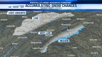
Saw this post from Ken Weathers earlier and really liked it, too. It's difficult to define amounts several days out, but this kind of graphic is useful to definite probabilities of accumulations at this point.
20211230_205847.jpg
The dynamics are interesting and would be one of the patterns in which we do get post cold front snow for the area. Things have to set up just right and still 3 to 4 days out.
 
  • Like
Reactions: headhunter15
Had a small QLCS tornado just east of Lake Guntersville. Probably a short lived EF-0 based on the radar data. Saw a sounding from UAH earlier that showed most of the storms near the TN state line having a hard time being surface based which is keeping the main severe risk just south.

View attachment 424371
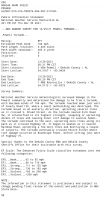
In case anyone is interested, here's the PNS issued for this tornado. Rated an EF1.
Screenshot_20211230-210442.png
 
  • Like
Reactions: norrislakevol
~Severe Weather Alert~ (Conditional)

There is an enhanced risk for strong to severe thunderstorms along and west of interstate 75. There is a slight risk for everyone else in East TN.

Timing: Saturday evening into the overnight hours.

Hazards:
- Damaging winds in excess of 60 mph is the primary hazard.
- Isolated tornadoes are also possible, with the highest chances in the southern valley and plateau. A strong tornado can't be ruled out in the enhanced risk areas.
 
Saturday is a tricky forecast. It's not the traditional severe weather outbreak setup with a lack of veering winds with height due to a neutral/negative tilted trough. We really don't even get much in the way of height falls across the Tennessee Valley ahead of the system. Think this lack of the neutral to negative trough will make it more difficult to erode the cap aloft, result in less instability, and mitigate cellular prefrontal severe convection development across MS/AL/TN. It's possible, but it's less likely. Definitely some strong speed shear, and if we can get some instability, we'll have that conditional risk of severe weather. Main risk is going to be damaging winds. In fact, going to have some pretty breezy conditions on Saturday ahead of the storms. We'll still need to watch for tornadic activity because of the very strong speed shear near the surface, and it should be a favorable setup for some potential QLCS tornadoes within the line of storms.

ConvectiveOutlookDay2.jpg

ConvectiveOutlookProbTorDay2.jpg

ConvectiveOutlookProbSvrWindDay2.jpg


Still not very confident in valley accumulating snow on Sunday night (it could happen but it's not likely at this point), but confidence is growing in some accumulating impactful snow for the mountains. All depends on the track of the surface low and where the mid-level frontogenic band sets up. Still probably see some snow in the valley, but any accumulations will depend on the snowfall rate with the warm surface.
 
  • Like
Reactions: kiloVOLt
Saturday is a tricky forecast. It's not the traditional severe weather outbreak setup with a lack of veering winds with height due to a neutral/negative tilted trough. We really don't even get much in the way of height falls across the Tennessee Valley ahead of the system. Think this lack of the neutral to negative trough will make it more difficult to erode the cap aloft, result in less instability, and mitigate cellular prefrontal severe convection development across MS/AL/TN. It's possible, but it's less likely. Definitely some strong speed shear, and if we can get some instability, we'll have that conditional risk of severe weather. Main risk is going to be damaging winds. In fact, going to have some pretty breezy conditions on Saturday ahead of the storms. We'll still need to watch for tornadic activity because of the very strong speed shear near the surface, and it should be a favorable setup for some potential QLCS tornadoes within the line of storms.

ConvectiveOutlookDay2.jpg

ConvectiveOutlookProbTorDay2.jpg

ConvectiveOutlookProbSvrWindDay2.jpg


Still not very confident in valley accumulating snow on Sunday night (it could happen but it's not likely at this point), but confidence is growing in some accumulating impactful snow for the mountains. All depends on the track of the surface low and where the mid-level frontogenic band sets up. Still probably see some snow in the valley, but any accumulations will depend on the snowfall rate with the warm surface.

Thank you for the detailed discussion of the upcoming system. I'm still on vacation right now, so i can't post very often.
 
  • Like
Reactions: MetVol
A glance at the visible satellite indicates we will have some peaks of sun today northern Alabama, central and eastern Tennessee. Models did a decent job at picking up on that a couple of days ago. The more sun these areas see, the greater the chances of discrete cells developing which is obviously where the greater risk for larger, longer track tornadoes will exist. Shear looks good....or bad depending on how you look at it lol.
 
A glance at the visible satellite indicates we will have some peaks of sun today northern Alabama, central and eastern Tennessee. Models did a decent job at picking up on that a couple of days ago. The more sun these areas see, the greater the chances of discrete cells developing which is obviously where the greater risk for larger, longer track tornadoes will exist. Shear looks good....or bad depending on how you look at it lol.
We are getting a mix of sun and clouds in Knoxville.
 
  • Like
Reactions: norrislakevol

VN Store


Back
Top