MetVol
🌪️⚡❄️☀️🎣
- Joined
- Dec 8, 2020
- Messages
- 240
- Likes
- 708
Not good in Campbell County going up I-75
I am in Charlotte. We got snow first. Then it changed over to sleet and freezing rain, but I'd say mostly sleet since it had not been tough to walk on with the pup. It's back to snow now.Who's in the Charlotte area? Did you get as much ice as it looked to be? You should be coming out of the worst of it.

So what’s the timing on those 2 events? The first one moving down from the Northwest doesn’t look like it’ll drop a ton of snow but that second storm coming from the Southwest looks pretty potent.For snow lovers, good news is that this pattern is going to favor some more snow chances over the next couple weeks at least. Was talking to a friend who deals much more closely with teleconnections forecasting, and he says it's lining up for colder than normal and above normal precip chances through late January/early February at least.
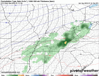
GFS is on board with that. Right now, it keeps showing a consistent southern storm track with cold air across our region. We'll see how it shakes out as we get closer.
View attachment 428810
@MetVol , I've already seen posts on social about the 5-7 day out. Sounds like you will probably have a few more opportunities this winter.
One mid-week isn't as impressive, mainly just a cold front (but a surface low may develop along it to drop some cold side snow in some areas), and the weekend is the other system. Lot of questions with the track, so we'll see. Storm track should favor several chances for winter weather the next couple weeks.So what’s the timing on those 2 events? The first one moving down from the Northwest doesn’t look like it’ll drop a ton of snow but that second storm coming from the Southwest looks pretty potent.
