You are using an out of date browser. It may not display this or other websites correctly.
You should upgrade or use an alternative browser.
You should upgrade or use an alternative browser.
East Tennessee Weather II
- Thread starter rocktopper16
- Start date
hUTch2002
Wait til next year!
- Joined
- Jul 30, 2018
- Messages
- 20,277
- Likes
- 23,265
Velo Vol
Internets Expert
- Joined
- Aug 19, 2009
- Messages
- 37,130
- Likes
- 17,632
My amateur theory was that it's because we have more humidity than the plains . . . which in reality is probably only a small factor.The terrain of the eastern U.S. does a lot to slow the progression of those cold airmasses. The situation we're seeing tonight usually happens with very dynamic systems where the temperature drop is aided by very strong ascent and dynamic cooling.
OK, the other weird thing about this is that often when there's abrupt temperature drop in autumn/winter we have a period of gusty winds immediately proceeding a sharp line of rain, and then after that the cold air comes.
This isn't that.
Matt2496
Well-Known Member
- Joined
- Dec 2, 2016
- Messages
- 14,157
- Likes
- 22,494
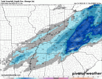
There are other models showing similar accumulations but when you take into account melting and compaction of snow accumulations will likely be less than that.That can’t be real right?
I'm more interested in the model trends and it's a very good sign when the major models are all trending upward the night before the event. Normally for us they trend the other way lol. It's nice to see the Valley in the bullseye of one of these systems for once.
Matt2496
Well-Known Member
- Joined
- Dec 2, 2016
- Messages
- 14,157
- Likes
- 22,494
hUTch2002
Wait til next year!
- Joined
- Jul 30, 2018
- Messages
- 20,277
- Likes
- 23,265
Well I wish we would get 9+ but I’ll “settle” for 4. Dang, I sound like my wife.There are other models showing similar accumulations but when you take into account melting and compaction of snow accumulations will likely be less than that.
I'm more interested in the model trends and it's a very good sign when the major models are all trending upward the night before the event. Normally for us they trend the other way lol. It's nice to see the Valley in the bullseye of one of these systems for once.
feathersax
Well-Known Member
- Joined
- Sep 20, 2008
- Messages
- 16,630
- Likes
- 33,077
MetVol
🌪️⚡❄️☀️🎣
- Joined
- Dec 8, 2020
- Messages
- 240
- Likes
- 708
MetVol
🌪️⚡❄️☀️🎣
- Joined
- Dec 8, 2020
- Messages
- 240
- Likes
- 708
There are other models showing similar accumulations but when you take into account melting and compaction of snow accumulations will likely be less than that.
I'm more interested in the model trends and it's a very good sign when the major models are all trending upward the night before the event. Normally for us they trend the other way lol. It's nice to see the Valley in the bullseye of one of these systems for once.
Yeah I prefer to look at the positive depth change in situations like this to account for the melting. Still significant accumulations and trend is up, up, up with totals.

Vol knight
Text a Buddy!
- Joined
- Oct 2, 2013
- Messages
- 8,984
- Likes
- 3,153
volsarelife1
Well-Known Member
- Joined
- Jul 15, 2017
- Messages
- 14,137
- Likes
- 18,107
volsarelife1
Well-Known Member
- Joined
- Jul 15, 2017
- Messages
- 14,137
- Likes
- 18,107
Vol knight
Text a Buddy!
- Joined
- Oct 2, 2013
- Messages
- 8,984
- Likes
- 3,153
volsarelife1
Well-Known Member
- Joined
- Jul 15, 2017
- Messages
- 14,137
- Likes
- 18,107
Vol knight
Text a Buddy!
- Joined
- Oct 2, 2013
- Messages
- 8,984
- Likes
- 3,153
Vol knight
Text a Buddy!
- Joined
- Oct 2, 2013
- Messages
- 8,984
- Likes
- 3,153


