norrislakevol
Well-Known Member
- Joined
- May 25, 2007
- Messages
- 7,946
- Likes
- 13,818
Someone wiser than me will have to explain but it’s not the surface temp. How would one of you more weather-savvy folks explain it?It’s time for the snow tradition - get in the truck and head to Waffle House. Temp shows 29 versus the official “31”, so there’s some hope yet this thing brings us a good snow. Trying to will this thing into existence.
Wait till this upcoming Friday night. It's a pretty good bet we see some type of wintry precip, and at least some snow...perhaps a quite significant amount.It’s time for the snow tradition - get in the truck and head to Waffle House. Temp shows 29 versus the official “31”, so there’s some hope yet this thing brings us a good snow. Trying to will this thing into existence.
If it's the "official" temperature being reported, then it just may not have been updated, and small changes in locality can make a big difference.. Temperatures generally cool rapidly with precip falling. In some instances, you can start out as rain and be around 34 degrees, if the precip gets heavy enough, you can get something called dynamic cooling (If conditions are right upstairs) changing the precip to all snow as the warm air in the atmosphere basically gets used up by melting the snow flakes into rain. As the precip lightens it can switch back to rain. This is just one small example. Tons and tons of factors at play.Someone wiser than me will have to explain but it’s not the surface temp. How would one of you more weather-savvy folks explain it?
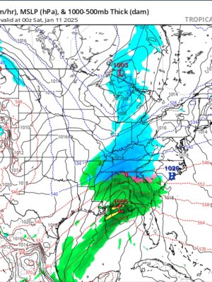
Lock it in, my man! Let’s do this. Fingers crossed for minimal change.Latest GFS run for the Friday/Sat event. It's keeping the Low south of us and indicating an all snow event. This will continue to change, but this run indicates 4 to 8 inches of accumulation for all of East Tennessee. This is based on a 10 to 1 liquid to snow ratio.
How we looking for the Friday possibility here in the Memphis area?
Yea. That Low current projected path is the perfect setup for snow in all of Tennessee bringing plenty of moisture up from the gulf. Just have to watch it as it can shift North though and bring warmer air up.. This is Friday midnight heading into Saturday Morning as of now.Latest GFS run for the Friday/Sat event. It's keeping the Low south of us and indicating an all snow event. This will continue to change, but this run indicates 4 to 8 inches of accumulation for all of East Tennessee. This is based on a 10 to 1 liquid to snow ratio.

Right, latest EURO run has a similar path to the GFS now, but a weaker storm. Around 1 to 2 inches for everyone in east Tennessee. The models will shift back and forth especially over the next 2 days before they get closer to locking in to a solution. We are certainly going to be set up for a good one as far as the pattern and ground temperatures go.Yea. That Low current projected path is the perfect setup for snow in all of Tennessee bringing plenty of moisture up from the gulf. Just have to watch it as it can shift North though and bring warmer air up.. This is Friday midnight heading into Saturday Morning as of now.
View attachment 712182
Couple of inches for East Tenn. Maybe 3-5 in some areas. As soon as it makes the northward turn, it is going to skeedaddle fast. Not going to stick around long enough to dump. But a lot can change in 4 days. Might just get slush.
Still looks like it may happen here but European and GFS has backed off its crazier, nearly identical solutions from 24, 36, and 48 hours ago...
Might be a daytime event here so temps will be more in question than east or west of here.
Really liking this setup and track even more now. Still too far out for specifics or details. But I wouldn't be shocked to see a winter storm warning be issued in the coming days. 4-8 inches from this one wouldn't surprise me at all.I'm just liking the way that low is tracking at the moment with having the cold air in place. We'll see if it plays out or not
Really liking this setup and track even more now. Still too far out for specifics or details. But I wouldn't be shocked to see a winter storm warning be issued in the coming days. 4-8 inches from this one wouldn't surprise me at all.
Going to have that gulf moisture with the cold air in place. Also may see some even colder air than expected when we get the northwest winds flowing with the snow pack from Kentucky
