rocktopper16
Spread sunshine, Not shade.
- Joined
- Jan 8, 2012
- Messages
- 11,714
- Likes
- 10,448
I hope so too..the guys over at AmericanWx seemed to have moved on they started the severe weather thread
The National Weather Service in Morristown has issued a
* Flood Advisory for...
Morgan County in east Tennessee...
Loudon County in east Tennessee...
Claiborne County in east Tennessee...
Anderson County in east Tennessee...
Knox County in east Tennessee...
Blount County in east Tennessee...
Hancock County in east Tennessee...
Campbell County in east Tennessee...
Sevier County in east Tennessee...
Scott County in east Tennessee...
Roane County in east Tennessee...
Union County in east Tennessee...
* Until 145 AM EST
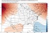
* At 939 PM EST, Doppler radar indicated light to moderate rain,
with some embedded heavy showers, moving across the area. Radar
indicates that amounts in excess of one inch has already fallen
across much of the advisory area, and additional rain is expected
over the next few hours. This will result in ponding of water in
poor drainage areas and may lead to flooding of some smaller
creeks and streams.
* Some locations that will experience flooding include...
Knoxville, Oak Ridge, Maryville, Sevierville, Clinton, Lenoir City,
Alcoa, La Follette, Kingston, Rockwood, Loudon, Gatlinburg, Oneida,
Maynardville, Sneedville, Wartburg, Farragut, Fairview, Pigeon
Forge and Oliver Springs.
The National Weather Service in Morristown has issued a
* Flood Warning for...
Morgan County in east Tennessee...
Bledsoe County in east Tennessee...
Claiborne County in east Tennessee...
Anderson County in east Tennessee...
Hancock County in east Tennessee...
Campbell County in east Tennessee...
Scott County in east Tennessee...
Roane County in east Tennessee...
Union County in east Tennessee...
* Until 445 AM EST/345 AM CST/
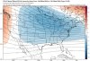
* At 1045 PM EST/945 PM CST/, Doppler radar indicated light to
moderate rain, with some embedded heavy showers, moving across the
area. Radar indicates that amounts of in excess of two inches have
already fallen across much of the warning area, and additional
rain is expected over the next few hours. This will cause flooding
of creeks and streams as well as ponding of water in low lying
areas.
* Some locations that will experience flooding include...
Oak Ridge, Clinton, Lenoir City, La Follette, Kingston, Rockwood,
Oneida, Maynardville, Pikeville, Sneedville, Wartburg, Fairview,
Oliver Springs, New Tazewell, Tazewell, Plainview, Jacksboro,
Huntsville, Pruden and Midtown.
its a weather discussion thread. Get over yourself. There is a post right above me that is copy and paste from WVLT. Everything in this thread can be found on your phone.