DarthVisor
Belee dat
- Joined
- Jul 20, 2008
- Messages
- 5,154
- Likes
- 43
The strength of these storms depend on how quick this cap we have currently erodes later on. The best chances for severe weather will be in Southeast KY and Southwest Virginia. I'm keeping my eye on Monday, as some portions of the Southern Valley and Middle TN may see a significant severe weather event.
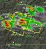
High risk of hail associated with this watch. It may get interesting tonight.
Storm Prediction Center Severe Thunderstorm Watch 10
The National Weather Service in Morristown has issued a
* Severe Thunderstorm Warning for...
Rhea County in east Tennessee...
Central Meigs County in east Tennessee...
Bledsoe County in east Tennessee...
* Until 645 PM EDT/545 PM CDT/
* At 603 PM EDT/503 PM CDT/, a severe thunderstorm was located 9
miles south of Spencer, moving east at 40 mph.
HAZARD...60 mph wind gusts and quarter size hail.
SOURCE...Radar indicated.
IMPACT...Hail damage to vehicles is expected. Expect wind damage
to roofs, siding, and trees.
* Locations impacted include...
Dayton, Pikeville, Decatur, Spring City, Graysville, Peakland,
Mount Crest, Big Spring, Evensville, Fall Creek Falls State Park,
Old Washington, Brayton and Old Cumberland.
The National Weather Service in Morristown has issued a
* Severe Thunderstorm Warning for...
Southwestern Rhea County in east Tennessee...
Southwestern Meigs County in east Tennessee...
Sequatchie County in east Tennessee...
Southwestern Bledsoe County in east Tennessee...
Northeastern Hamilton County in east Tennessee...
* Until 730 PM EDT/630 PM CDT/
* At 638 PM EDT/538 PM CDT/, a severe thunderstorm was located 9
miles northeast of Gruetli-Laager, or 13 miles northwest of Dunlap,
moving east at 40 mph.
HAZARD...60 mph wind gusts and half dollar size hail.
SOURCE...Radar indicated.
IMPACT...Hail damage to vehicles is expected. Expect wind damage
to roofs, siding, and trees.
* Locations impacted include...
Dayton, Dunlap, Soddy-Daisy, Graysville, Flat Top Mountain, Sale
Creek, Palio, Brayton, Birchwood, Shady Grove, Cagle, Old
Cumberland and Mowbray Mountain.
The National Weather Service in Morristown has issued a
* Severe Thunderstorm Warning for...
Southern Rhea County in east Tennessee...
Central Meigs County in east Tennessee...
McMinn County in east Tennessee...
* Until 730 PM EDT
* At 637 PM EDT, a severe thunderstorm was located over Dayton,
moving east at 40 mph.
HAZARD...60 mph wind gusts and quarter size hail.
SOURCE...Radar indicated.
IMPACT...Hail damage to vehicles is expected. Expect wind damage
to roofs, siding, and trees.
* Locations impacted include...
Athens, Dayton, Decatur, Etowah, Englewood, Graysville, Niota,
Calhoun, Riceville, Hillsview, Clear Water, Big Spring, Evensville,
Old Washington and Dentville.
...SIGNIFICANT WEATHER ADVISORY FOR NORTHEASTERN LOUDON...SOUTH
CENTRAL ANDERSON...SOUTHWESTERN KNOX...NORTHWESTERN BLOUNT AND ROANE
COUNTIES UNTIL 730 PM EDT...
At 646 PM EDT, Doppler radar was tracking a strong thunderstorm near
Rockwood, moving east at 55 mph.
Half inch hail and winds in excess of 40 mph will be possible with
this storm.
Locations impacted include...
Knoxville, Oak Ridge, Lenoir City, Alcoa, Kingston, Rockwood, Loudon,
Farragut, Fairview, Louisville, Rockford, Eagleton Village, Midtown,
Harriman, Friendsville, Bradbury, Eagle Furnace, Karns, Wildwood and
Lake Forest.
The National Weather Service in Morristown has issued a
* Severe Thunderstorm Warning for...
Loudon County in east Tennessee...
Southern Knox County in east Tennessee...
Blount County in east Tennessee...
Central Roane County in east Tennessee...
* Until 745 PM EDT
* At 659 PM EDT, a severe thunderstorm was located near Loudon,
moving east at 70 mph.
HAZARD...60 mph wind gusts and quarter size hail.
SOURCE...Radar indicated.
IMPACT...Hail damage to vehicles is expected. Expect wind damage
to roofs, siding, and trees.
* Locations impacted include...
Knoxville, Oak Ridge, Maryville, Lenoir City, Alcoa, Kingston,
Loudon, Farragut, Louisville, Rockford, Eagleton Village, Midtown,
Smoky Mountains-Fontana Area, Harriman, Greenback, Friendsville,
Philadelphia, Townsend, Walland and Clover Hill.
...A SEVERE THUNDERSTORM WARNING REMAINS IN EFFECT UNTIL 730 PM EDT
FOR SOUTHEASTERN RHEA...SOUTHWESTERN MEIGS AND MCMINN COUNTIES...
At 702 PM EDT, a severe thunderstorm was located near Decatur, moving
east at 30 mph.
HAZARD...Ping pong ball size hail and 60 mph wind gusts.
SOURCE...Radar indicated.
IMPACT...People and animals outdoors will be injured. Expect hail
damage to roofs, siding, windows, and vehicles. Expect wind
damage to roofs, siding, and trees.
Locations impacted include...
Athens, Decatur, Etowah, Englewood, Niota, Calhoun, Riceville,
Hillsview, Clear Water, Old Washington, Big Spring and Dentville.