East Tennessee Weather II

Good, it won't kill the trees but maybe it'll destroy those awful Bradford Pear blooms that stink like holy hell.
They only last a few weeks anyway. Smell like sweaty gym socks. Soft wood, branches tear off, who would want one?
 
They only last a few weeks anyway. Smell like sweaty gym socks. Soft wood, branches tear off, who would want one?

Agreed! They're hybrid trees, they are more dangerous than most people think. My neighbor had a giant branch break off during a storm in his front yard. It was half blocking his front door and dented up one of his vehicles. I'm not sure who would want one.
 
Last edited:
I really think it’ll be only be at the max 3 days of real cold. Lows overnight will start to dip down back to the 30’s but it’s still worrisome for farmers, especially Florida.

THE peach farmers are taking a hit. They don’t have anywhere close to enough chill hours this season. Sad.
 
Are these lows I am seeing for this weekend right? My weather channel app is saying 28° for friday or sat night.
 
Alert!!!!

...FLOOD WATCH REMAINS IN EFFECT FROM 1 PM EST /NOON CST/ THIS
AFTERNOON THROUGH THURSDAY EVENING...

The Flood Watch continues for

* Portions of Southwest North Carolina and East Tennessee,
including the following areas, in Southwest North Carolina,
Cherokee and Clay. In East Tennessee, Anderson, Bledsoe,
Blount Smoky Mountains, Bradley, Campbell, Claiborne, Cocke
Smoky Mountains, East Polk, Grainger, Hamblen, Hamilton,
Jefferson, Knox, Loudon, Marion, McMinn, Meigs, Morgan, NW
Blount, North Sevier, Northwest Cocke, Northwest Monroe, Rhea,
Roane, Scott TN, Sequatchie, Sevier Smoky Mountains, Southeast
Monroe, Union, and West Polk.

* From 1 PM EST /noon CST/ this afternoon through Thursday
evening

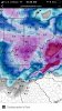
* Rain amounts between 2 and 2.5 inches are expected. Amounts in
excess of 3 inches are likely across the southern watch area
with isolated amounts up to 4 inches. This may cause flooding
of low lying areas, streets, and cause creeks and streams to
come out of their banks.

* People in the watch area should be aware of the threat of
heavy rainfall. Avoid low lying areas...and be careful when
approaching highway dips and underpasses. If you come to a
closed or flooded road...Turn around! Don`t drown!
 
Is this rain event going to be limited to our area, or will it be in middle Tennessee as well?
 
Well it looks like everything that has budded early around here is about to get wiped out in the next week or so.
 
Through 3-13.


I’ll show myself out the door.
 

Attachments

  • 269A2ECD-89A1-4385-AB29-20A6562AFCC3.jpg
    269A2ECD-89A1-4385-AB29-20A6562AFCC3.jpg
    100.3 KB · Views: 4
Crazy wind came through with this cold front just now. Where were you guys on that news?
 
Crazy wind came through with this cold front just now. Where were you guys on that news?

There's not much to say other than some gusty winds along the frontal passage. Morristown didn't issue a wind advisory.
 
Had a dusting of snow on the cars this morning...I've turned the page though..bring on spring!
 

VN Store


Back
Top