East Tennessee Weather II

Is all the bugs worked out of it yet?
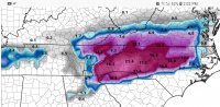
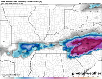
With this new model, they won't be using as much resources as the old GFS. Also, it will be more High resolution, so hopefully, they'll be able to nail down forecasts at a more local level. I'm still trying to figure out what its bias is going to be, and this system will be a good test to find out.
 
Last edited:
NOAA forecast is saying we can expect 5-9 inches.

Weather.com and wunderground saying 50% chance of 1-3 inches.

Local news says 4-8 inches.

Another local station showed the latest GFS model, which has 0 inches here.

I don't know WTF to do about Sunday, we're closing in on decision time and I'd rather not toss away the money if I don't need to.

Where are you located? I can't give out an official forecast yet, but I do have a good idea of where the hardest hit areas will be.
 
NOAA forecast is saying we can expect 5-9 inches.

Weather.com and wunderground saying 50% chance of 1-3 inches.

Local news says 4-8 inches.

Another local station showed the latest GFS model, which has 0 inches here.

I don't know WTF to do about Sunday, we're closing in on decision time and I'd rather not toss away the money if I don't need to.
Town?
 
Considering that you are under a Winter Storm Watch, I would say that you have a pretty good chance of seeing a good amount of snow.
I'd usually agree, but we've had a few of those watches and warnings for other events lately and gotten nothing.
 
I'd usually agree, but we've had a few of those watches and warnings for other events lately and gotten nothing.

Generally, watches and warnings like that aren't just issued on a whim. Sure, there's always a chance that it might not pan out the way they are thinking. However, they obviously have enough confidence to issue a watch, and watches should always be taken seriously, IMO. The way I've looked at storms in recent years is that it's better to be prepared than not to be. If nothing happens, great. If it does get bad, you've got nothing to worry about.
 
Last edited:
The 12z Euro is running right now, so I'll be giving an update on all of the latest model runs around 1:30 or so.
 
2 trains of though on this... I'm working so generally speaking that means a buttload of snow to fall (at least where I'm working anyways.)

I had crappy tires so I just dropped a grand on 4 new ones because of the winter weather - I want to get home after work - so it won't snow because of the new tire purchase.

So 50/50 based on that. Probably snows in Johnson City, while it does nothing/cold rains towards Kingsport way.
It won’t snow in Kingsport because Eastman ruins it every time.
 
  • Like
Reactions: kayakonthefly
12z Old GFS:

gfs_asnow_seus_15.png


12z NAM:

namconus_asnow_seus_21.png


12z Canadian:

gem_asnow_seus_10.png


12z GFS FV3:
 

Attachments

  • Screenshot_20181207-140236_Firefox.jpg
    Screenshot_20181207-140236_Firefox.jpg
    1.2 MB · Views: 20
Plateau looks pretty good too
The thing I dont understand is why is Claiborne county included in the watch and not the rest of the Northern Plateau (Campbell, Morgan, and Scott counties). It's not like they are getting more snow on the models.
 
I'll post it. Not sure how reliable it is since it's new.
 

Attachments

  • 1330817520_snku_acc.us_ov(1).thumb.png.76152a381556f0fa51d7fd8c696328eb.png
    1330817520_snku_acc.us_ov(1).thumb.png.76152a381556f0fa51d7fd8c696328eb.png
    631.7 KB · Views: 15

VN Store


Back
Top