East Tennessee Weather II

As far as the next few weeks, I'm not liking what I'm seeing on the models. Unfortunately, February will probably be a better month for us in terms of wintry weather.
 
Dusting of snow on way to work this morning...always nice to see the white stuff
 
Some reason for concern. The hp get trapped and cold air stays around a bit longer. The slp is sliding further south.
 
VK. Every model run is showing cooler and cooler temps. The mild may not be so mild. Freezing rain is starting to be a concern.


And another Nor’easter next week? Fantasy run.

I refuse to trust a model until a day now.
 
I'm thinking that we could see 5+ hours of wintery weather Sunday night...but will eventually turn to rain on Monday...definitely worth watching

I just don’t see a model worth trusting the RGEM is throwing out crazy freeing rain numbers.
 
Gem still sticking with a Freezing event. With small snow amounts. WRX saying to monitor the forecast as well.
 

Attachments

  • E46652C0-B9FE-460B-BBE5-9A4AA9477B79.jpg
    E46652C0-B9FE-460B-BBE5-9A4AA9477B79.jpg
    75.8 KB · Views: 1
It truly baffles me that it can be so cold with arctic temperatures in East TN and we can’t sniff precipitation. However, as soon as it gets above freezing, we get precipitation in the form of rain.
 
  • Like
Reactions: 2 people
This sucks. I have the thermostat at 73 degrees, it says it’s 73 in the house, but this chill won’t go away. Currently about 27 degrees outside. I just can’t get warm without running a space heater next to me.
 
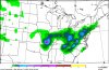
NAM still trending cooler. Waiting for the GFS which had .25-.35 of freezing rain for most of the area.

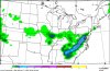
Really need to follow this storm. Has potentional to be a very serious situation.
 

Attachments

  • 9021CFB8-A5E1-49E9-A641-1EA73B66297C.png
    9021CFB8-A5E1-49E9-A641-1EA73B66297C.png
    553.1 KB · Views: 2
MRX recalling the 2015 event. Thinking northerly winds could keep the area under freezing Monday. Looks like the Precip may be light though.
 
I don't look at models this far out..but what the heck...nothing else going on this time of year
snku_acc.us_ov.png
 
  • Like
Reactions: 1 person
MRX recalling the 2015 event. Thinking northerly winds could keep the area under freezing Monday. Looks like the Precip may be light though.

That's not exactly what they are saying. They're saying that they're keeping an eye on the potential, but they expect SW winds to build in Monday and change the mix to all rain.
 
That's not exactly what they are saying. They're saying that they're keeping an eye on the potential, but they expect SW winds to build in Monday and change the mix to all rain.

One thingwe`ve been looking for is a possible stubborn northerly wind in thevalley that might keep temps in the afternoon below freezing--as wasseen with the ice event in Feb 2015. Right now, it looks like thepressure pattern “will try” to keep a SW flow up the valley on Monday,that will help with warm advection.
 

VN Store


Back
Top