rocktopper16
Spread sunshine, Not shade.
- Joined
- Jan 8, 2012
- Messages
- 11,693
- Likes
- 10,406
Can you find a wind speed forecast for Monday? Im out and about and cant get it to load
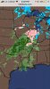
Models didnt have it as Far East as it is now. Much more moisture with it too.
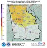
WWA for all of ET now
National Weather Service Watch Warning Advisory Summary Market TN&product1=Winter+Weather+Advisory&lat=36.103&lon=-83.5573
Is that user on American WX legit? I read where he said portions of Southeast TN meet the criteria for ICE storm warning? 12 Z NAM show a increase in moisture.