East Tennessee Weather II

I live in Greenback and my forecast is calling for 3-5 inches during the day and 1-3 in the evening. They sure are throwing out some big numbers.
There seems to be a strange amount of uncertainty given it’s hitting tomorrow. For Knoxville they’re saying 1-3 during the day and additional accumulation that evening but they’re not saying amounts.
 
Couple of inches for East Tenn. Maybe 3-5 in some areas. As soon as it makes the northward turn, it is going to skeedaddle fast. Not going to stick around long enough to dump. But a lot can change in 4 days. Might just get slush.
I'm still sticking with this. I live in Walland between Maryville and Seymour. This is my forecast for this area lol.
 
I’m surprised I haven’t seen posts this morning about the storm. You all are usually all over it. Now that we’re about 24 hours from the start, has anything changed? Are we still thinking 4-6? I’m in West Knoxville so I’m curious about that area in particular. It seems like this is one it’s better to be West.

One more question, I haven’t seen any posts from @MetVol. Is Met still around? He (or she but I’m fairly sure he) was always very knowledgeable and I enjoyed the posts.
Yep I'm still thinking 3-6 for most of the area. With some 6-8 in a few areas still possible. Could see a bit more sleet/freezing rain in the southern part of the area. But for the most part I think majority will still be seeing a pretty decent snow from this one
 
  • Like
Reactions: hUTch2002
There seems to be a strange amount of uncertainty given it’s hitting tomorrow. For Knoxville they’re saying 1-3 during the day and additional accumulation that evening but they’re not saying amounts.
Almost every model is agreeing on 6+ for the valley. The 3K NAM model threw a wrench in that and is showing some warmer air pushing into the valley which would knock down snow totals.

I'd prepare for the higher totals to be safe. Even if we only get 3 or 4 inches, the cold will keep refreezing it.
 
  • Like
Reactions: hUTch2002
Almost every model is agreeing on 6+ for the valley. The 3K NAM model threw a wrench in that and is showing some warmer air pushing into the valley which would knock down snow totals.

I'd prepare for the higher totals to be safe. Even if we only get 3 or 4 inches, the cold will keep refreezing it.
What website do you use for the models?
 
What website do you use for the models?
That 3k NAM is probably what made NWS Morristown back off totals a bit. All the other short range models seems to be agreeing with what the GFS has shown all week.


That 3k NAM is probably what made NWS Morristown back off totals a bit. All the other short range models seems to be agreeing with what the GFS has shown all week.


I wonder, now that the storm is developing and starting to track this direction, is it leaning more towards the GFS model or the NAM? Gonna be fun to watch.
 
That 3k NAM is probably what made NWS Morristown back off totals a bit. All the other short range models seems to be agreeing with what the GFS has shown all week.
MRX dropping snow totals because of warm air pushing in also means there's going to be icing which they haven't even mentioned yet.

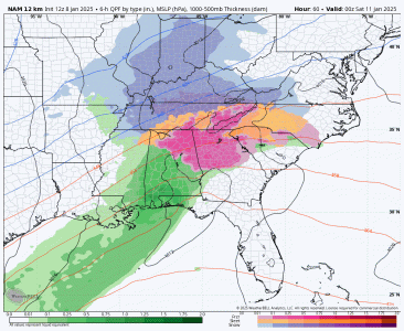
Here's that NAM model. Take with a grain of salt but if this happens you're talking about a huge problem.

c9L2m37.gif
 
MRX dropping snow totals because of warm air pushing in also means there's going to be icing which they haven't even mentioned yet.

Here's that NAM model. Take with a grain of salt but if this happens you're talking about a huge problem.

View attachment 713246
This reminds me of the ice storm we had several years ago. 2014? Difference in this, is that there will be more snow mixed in.

Yeah, our area isn’t prepared for this if it happens
 
Really liking this setup and track even more now. Still too far out for specifics or details. But I wouldn't be shocked to see a winter storm warning be issued in the coming days. 4-8 inches from this one wouldn't surprise me at all.

Going to have that gulf moisture with the cold air in place. Also may see some even colder air than expected when we get the northwest winds flowing with the snow pack from Kentucky
1000008005.jpg
 
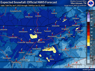
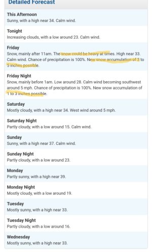
MRX has Knoxville anywhere from 2 to 4 or 3 to 5 Friday with an additional 1 to 3 Friday Night in the detailed forecast I posted below.
Screenshot_20250109_132858_Chrome.jpg


A lot of our winter weather starts falling usually with the ground/roads warm so it takes a few hours to start laying or it doesn't start laying until the sun sets. This will not be the case tomorrow. We have been in a decent cold spell for a couple of weeks. As soon as this starts falling tomorrow and at the heavy rate they're predicting, it will immediately start laying especially on non-treated roads or subdivision roads.

You won't be able to see the first flake fly, decide to leave work, and make it home without a four wheel drive. This will catch everyone off guard with wrecks everywhere so it's a really good idea to stay home tomorrow if you can.
 
Really liking this setup and track even more now. Still too far out for specifics or details. But I wouldn't be shocked to see a winter storm warning be issued in the coming days. 4-8 inches from this one wouldn't surprise me at all.

Going to have that gulf moisture with the cold air in place. Also may see some even colder air than expected when we get the northwest winds flowing with the snow pack from Kentucky
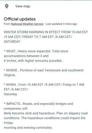
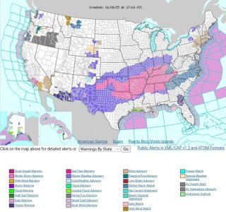
Still sticking to my original thoughts with this one. Got the winter storm warning issued as expected. Now thinking that 4-8+ inches of snow will be happening. Got all the ingredients in place to play out
 

VN Store


Back
Top