Vol knight
Text a Buddy!
- Joined
- Oct 2, 2013
- Messages
- 8,958
- Likes
- 3,141
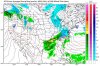
I'll say this: The GGEM has been the most consistent model out of all of them. It has not waivered in dumping a lot of snow here.
I'd also like to mention that the RGEM, the Canadian short range model, called the storm that happening right now correctly. It was thrown out by the local news guys.
Not seen that, everything I see is a high of 38.
TWC has 44 as a high for me on Monday..with ice in the morning and changing to rain during the day...tomorrow will be the day when all the forecasts start coming together..I'm leaning now toward seeing snow Sunday night and changing to rain on Monday and maybe back to snow Monday night..with limited accumulation..hopefully that will change with new models

")