East Tennessee Weather

Status
Not open for further replies.
12z GEM run:

9u2IHFd.gif
 
we were supposed to maybe get a trace and the forecast high was 41..instead we got 2.5 inches and it got up to 32
bartolo-colon-swing-and-miss-against-pirates-b.gif
 
JC, I didn't really pay much attention to the models other than the GFS for the clipper that just moved through. What I didn't notice is that the GEM correctly showed this system, while the GFS and other models didn't. Maybe we shouldn't just dismiss the GEM entirely, like the local news guys did.
 
JC, I didn't really pay much attention to the models other than the GFS for the clipper that just moved through. What I didn't notice is that the GEM correctly showed this system, while the GFS and other models didn't. Maybe we shouldn't just dismiss the GEM entirely, like the local news guys did.

Yeah I didn't check that one..I knew there would be some precip but I never thought it would hold together over the plateau like it did
 
JC and RT, I'd like to hear your opinions on the following quote from another weather enthusiast.

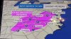
I think this is an issue playing into our coming storm. Over doing it on temps and eroding them too quickly. Remember for Knox it was supposed to switch to rain and warm dramatically today. KTYS sitting at freezing at 3PM.... Warm up is likely not going to happen today as originally forecast. Could see this same scenario Monday, cold was not eroded so easily with even moderate snows at times this morning but honestly mostly light snow. With potentially pre-dawn moderate to heavy snow with the coming storm I have some doubts about eroding the cold at least as far north as I-40. Not to mention I believe surface dew points Sun night will allow for some dynamic cooling for a time as well.
 
JC and RT, I'd like to hear your opinions on the following quote from another weather enthusiast.

That's what I was thinking..now we have snow pack to keep temps down as well as potentially getting colder because of the lower high temps
 
Here is the latest from the NWS

ANOTHER STRONGER STORM SYSTEM WILL MOVE INTO THE AREA LATE SUNDAY
NIGHT THROUGH MONDAY NIGHT. WITH ARCTIC AIR IN PLACE ACROSS THE
REGION...WIDESPREAD ACCUMULATING SNOWFALL WILL BE POSSIBLE. AS
TEMPERATURES WARM AS EARLY AS SUNDAY NIGHT AND CONTINUING DURING
THE DAY MONDAY...SNOW COULD MIX WITH RAIN...FREEZING RAIN...AND
SLEET...BEFORE CHANGING BACK TO SNOW LATE MONDAY NIGHT...ESPECIALLY
IN THE HIGHER ELEVATIONS ALONG THE NORTH CAROLINA MOUNTAINS WHERE
SIGNIFICANT SNOWFALL ACCUMULATIONS ARE POSSIBLE BY TUESDAY MORNING.
ANOTHER WEAKER SYSTEM WILL MOVE INTO THE REGION FROM THE NORTHWEST
TUESDAY NIGHT WITH MORE SNOW SHOWERS POSSIBLE ESPECIALLY IN THE
HIGHER ELEVATIONS.

SPECIFIC FORECAST DETAILS REGARDING PRECIPITATION AMOUNTS...TYPE...AND
THE TIMING ARE STILL SOMEWHAT UNCERTAIN AT THIS TIME.
 
JC, Idk about you, but I'm not buying that GFS run. To me, it looked like a frontal passage, which makes no sense. There was no southern development on that run. Just an amped up clipper.
 
Last edited:
Anyone follow WxSouth on Facebook? If not I highly suggest it. They are usually pretty good about tracking the weather and providing detailed info. Their last post goes into lots of detail on this storm.
 
Status
Not open for further replies.

VN Store


Back
Top