Orange_Vol1321
Well-Known Member
- Joined
- Dec 4, 2012
- Messages
- 28,188
- Likes
- 42,296
THE NATIONAL WEATHER SERVICE IN MORRISTOWN HAS ISSUED A
* FLOOD WATCH FOR PORTIONS OF SOUTHWEST NORTH CAROLINA...EAST
TENNESSEE AND SOUTHWEST VIRGINIA...INCLUDING THE FOLLOWING
AREAS...IN SOUTHWEST NORTH CAROLINA...CHEROKEE AND CLAY. IN
EAST TENNESSEE...ANDERSON...BLEDSOE...BLOUNT SMOKY MOUNTAINS...
BRADLEY...CAMPBELL...CLAIBORNE...COCKE SMOKY MOUNTAINS...EAST
POLK...GRAINGER...HAMBLEN...HAMILTON...HANCOCK...HAWKINS...
JEFFERSON...JOHNSON...KNOX...LOUDON...MARION...MCMINN...
MEIGS...MORGAN...NW BLOUNT...NORTH SEVIER...NORTHWEST CARTER...
NORTHWEST COCKE...NORTHWEST GREENE...NORTHWEST MONROE...
RHEA... ROANE...SCOTT TN...SEQUATCHIE...SEVIER SMOKY
MOUNTAINS... SOUTHEAST CARTER...SOUTHEAST GREENE...SOUTHEAST
MONROE... SULLIVAN...UNICOI...UNION...WASHINGTON TN AND WEST
POLK. IN SOUTHWEST VIRGINIA...LEE...RUSSELL...SCOTT...
WASHINGTON AND WISE.
* THIS AFTERNOON THROUGH TUESDAY MORNING.
* PERIODS OF MODERATE TO LOCALLY HEAVY RAINFALL WILL CONTINUE TO
OVERSPREAD THE REGION THIS AFTERNOON AND EVENING. WIDESPREAD
RAINFALL ACCUMULATIONS OF 1.5 TO 2 INCHES THROUGH TUESDAY
MORNING...WITH A FEW LOCALLY HIGHER AMOUNTS ALONG THE CUMBERLAND
PLATEAU.
* RUNOFF FROM MODERATE TO LOCALLY HEAVY RAINFALL ON TOP OF A FROZEN
GROUND WILL CAUSE FLOODING OF POOR DRAINAGE AND LOW-LYING
AREAS...PARTICULARLY IN AREAS THAT WILL HAVE A MELTING SLEET OR
SNOW PACK.
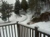
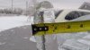
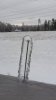
Does anyone remember the storm this time last year? Before that storm, we thought we were going to see significant amounts of snow. Instead, we got a Significant amount of Freezing Rain and Ice.Knoxville got close to a half inch of ice, while some areas in the Plateau saw almost an inch.
Since it's colder than expected, any chance for accumulating snow in the early morning?
 lol:
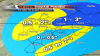
lol:There's a chance for some snow tomorrow morning, with a trace - 0.5 inch possible in the Central Valley, up to 2 inches possible in the northern counties, Plateau, and Mountains.
Which means get ready for an inch or 2 in the valley, lol.
A warm front is approaching tonight from the south, so the rain won't refreeze tonight. If anything, the temps will be steadily rising through the night.
Aldrich says we may see some snow showers overnight....he said I was in the 4-8 inch zone yesterday..so he owes me 3.999 inches..makes me angry those Hamblen County folks got snow and we didn't they don't appreciate it or deserve it..or maybe I'm bitter because they beat us 3/4 years in high school
And between Midnight and 8 AM, SNOW SHOWERS may RETURN and cause bigger problems during the morning commute.