Special Weather Statement
National Weather Service Morristown TN
432 AM EST Wed Jan 4 2017
NCZ060-061-TNZ012>018-035>047-067>074-081>087-098>102-VAZ001-002-
005-006-008-041745-
Cherokee-Clay-Scott TN-Campbell-Claiborne-Hancock-Hawkins-
Sullivan-Johnson-Morgan-Anderson-Union-Grainger-Hamblen-
Northwest Cocke-Cocke Smoky Mountains-Northwest Greene-
Southeast Greene-Washington TN-Unicoi-Northwest Carter-
Southeast Carter-Roane-Loudon-Knox-Jefferson-NW Blount-
Blount Smoky Mountains-North Sevier-Sevier Smoky Mountains-
Sequatchie-Bledsoe-Rhea-Meigs-McMinn-Northwest Monroe-
Southeast Monroe-Marion-Hamilton-Bradley-West Polk-East Polk-Lee-
Wise-Scott-Russell-Washington-
Including the cities of...Murphy...Hayesville...Oneida...
La Follette...Tazewell...Sneedville...Rogersville...Kingsport...
Bristol...Mountain City...Wartburg...Clinton...Oak Ridge...
Maynardville...Rutledge...Morristown...Newport...Cosby...
Greeneville...Cedar Creek...Johnson City...Erwin...Elizabethton...
Roan Mountain...Kingston...Lenoir City...Knoxville...Dandridge...
Maryville...Cades Cove...Sevierville...Gatlinburg...Dunlap...
Pikeville...Dayton...Decatur...Athens...Madisonville...
Coker Creek...Jasper...Chattanooga...Cleveland...Benton...
Ducktown...Jonesville...Wise...Norton...Gate City...Lebanon...
Abingdon
432 AM EST Wed Jan 4 2017 /332 AM CST Wed Jan 4 2017/
...Winter Weather Expected Across The Area Thursday Evening
Through Friday...
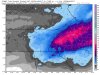
An arctic airmass will move into the area Thursday evening ushering
in some accumulating snow and much colder temperatures.
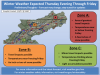
Starting Thursday evening and ending Friday night, areas of
southwest Virginia and higher elevations of northeast Tennessee
could expect to see snowfall accumulations of 1 to 3 inches.
Elsewhere across the area north of I-40 totals of 1-2 inches are
possible while southeast Tennessee and southwest North Carolina
will likely see only a dusting to 1 inch of snow.
Greatest impacts to travel will be in southwest Virginia and
northeast Tennessee where temperatures will barely climb to
freezing on Friday. This may lead to some slick spots and travel
hazards particularly on secondary and untreated roads, bridges and
overpasses. Throughout the area, please use caution when traveling
Thursday night and Friday. Slow down and allow yourself extra time
to reach your destination.