East Tennessee Weather

Status
Not open for further replies.
~VK's Severe Weather Discussion~

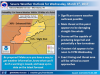
I said before that I would wait to post potential threats with this system, but I do have an update on that. The NWS SPC is expecting a widespread damaging wind threat with this upcoming system. There's a possibility that we could see a Derecho on Wednesday.

For those who don't know what a Derecho is, it's a long lasting, very fast squall line that can produce widespread wind damage. Typically, most of the derecho will have at least 58 mph wind speed (the minimum speed for a severe thunderstorm), with parts of the line having winds 75+ mph. They can do more damage than tornadoes, as they can travel over 250 miles in distance.

I'll post more tomorrow. There still could be some changes.
I hope not. I was in that one last summer up in JC and it was crazy how much damage it did to trees and boat docks.
 
Update:

There are some things about this system that are starting to become a little more clear, and other things that remain an uncertainty at this time. I'll start out with the threats.

Primary threats:

- Damaging straight line winds up to 70 MPH is the biggest threat.

- Large hail and a few tornadoes are possible.

- Flooding could also be an issue in some low lying areas.


Timing:

There's still quite a bit of uncertainty with the timing. The GFS is showing the system moving in around midday Wednesday, while the Euro and NAM are showing the system move in during the late afternoon/early evening time frame. Morristown has given a wide potential time frame between Noon and 9 PM.

Will knoxville get hit pretty hard in this? Or does it seem to be trending more north?
 
I hope not. I was in that one last summer up in JC and it was crazy how much damage it did to trees and boat docks.

One of the dangdest things I seen. Sitting in the station, nothing going on, wife calls and asks what is up with the weather and why were they no reports of severe possible. No clue what she is talking about. 5 minutes later, bam. Was shaking the rescue truck and ambulance inside the bay, blew crap everywhere. No warning, no nothing. Could literally see the wind traveling towards us.
 
One of the dangdest things I seen. Sitting in the station, nothing going on, wife calls and asks what is up with the weather and why were they no reports of severe possible. No clue what she is talking about. 5 minutes later, bam. Was shaking the rescue truck and ambulance inside the bay, blew crap everywhere. No warning, no nothing. Could literally see the wind traveling towards us.
Yeah, I was just about to eat outside with my family at the lake. We had literally finished watching the local weather 5 minutes earlier and got the all clear. Then we heard the wind and I had everybody run inside and get in the basement. We were lucky.
 
Yeah, I was just about to eat outside with my family at the lake. We had literally finished watching the local weather 5 minutes earlier and got the all clear. Then we heard the wind and I had everybody run inside and get in the basement. We were lucky.

when did this happen and what town ?
 
Last summer in East TN. The Johnson City/Elizabethton area got hit the hardest. Trees were down everywhere, boatdocks were flipped. There was zero warning as to it happening, and I would imagine that had I been on a boat with my family we would probably be dead. It came out of nowhere.

Storm that killed 3 in East Tennessee was a derecho


If I remember correctly, the weather had literally just went off the tv, and they were talking about it being partly cloudy or something. No mention of severe weather or anything, and then it just hit. I think the news/weather didn't mention it until after it was over.
 
If I remember correctly, the weather had literally just went off the tv, and they were talking about it being partly cloudy or something. No mention of severe weather or anything, and then it just hit. I think the news/weather didn't mention it until after it was over.

The news and NWS were talking about the storms before hand. I even posted about it on here.
 
The news and NWS were talking about the storms before hand. I even posted about it on here.

This was one of the local channels up this way. Usually they're spot on when it starts breaking, but no warnings across the tv or anything that I remember. I was working so there's a good possibility that I missed it, or didn't pay attention. I have to be out in it anyways, so what does it really matter.

On a side note - what do you think of the possibilities after this weekend of low 20's hitting? I'm debating on setting out my broccoli and onions.
 
Overall, it's over for the most part. I can't rule out a March surprise though.

Speaking of late snows, I was watching WATE 6 news one day, and one of the meteorologists was talking about how it can actually snow in East TN as late as April. I think it was in April of 1986 or 1987, but there was a snowstorm that dumped 10 inches of snow in Knoxville.

March 12, 1993. The night that Alan Houston played his final game for TN in the SECT in Lexington. KY 101 TN 40, then the blizzard of the century rolled in. Some people lost electricity for more than a week.
 
March 12, 1993. The night that Alan Houston played his final game for TN in the SECT in Lexington. KY 101 TN 40, then the blizzard of the century rolled in. Some people lost electricity for more than a week.

There was a hell of a lot more than 10 inches dumped in the blizzard of 93..lol. More like closer to two feet.
 
Severe weather outlook update:

The Enhanced risk area has expanded east to now include almost all of East Tennessee except Bristol and Johnson City.
 
I can't say I've ever experienced a Derecho but two or 3 years ago there was a line of storms that moved through the Knoxville area. This was in the evening between 5 and 7. The front was moving through at a steady pace. Everything about it seemed normal, wind, lightning, pouring rain but what nobody could see/predict were the microbursts this thing was throwing. I'm standing in the kitchen which is at the back of the house and behind the house we have a small treeline of mostly maples. In a period of about a second and a half I see the tops of the trees start to bend downward towards the porch followed by foliage debris and the sounds of the wall in front of me flexing. I've never moved away from a window faster in my life because I was sure either a branch was coming through them or they were about to be blown in on me. Luckily that never happened.
 
There are school systems that are preclosing because of these storms. Meigs and Athens are among them. That's crazy, Ive never seen that before.
 
Last edited:
There are school systems that are preclosing because of these storms. Meigs and Athens are amomg them. Thats crazy, Ive never seen that before.

I haven't seen that either, but I can understand why they are closing. These storms tomorrow are no joke, and they'll be coming around the time schools let out.
 
Update for tomorrow:

The chances of seeing a Derecho tomorrow is increasing. Morristown is now starting to mention the possibility of a Derecho.

Edit: Even Todd Howell is saying Derecho.
 
Last edited:
Status
Not open for further replies.

VN Store


Back
Top