East Tennessee Weather II

I know stuff can be unpredictable, but does anyone else in Knoxville think it’s weird that we never got a tornado warning alert? I did get a dangerous wind alert, but that was odd too.

Two different times this year a tornado has occurred and NWSM hasn't issued a tornado warning
 
I know stuff can be unpredictable, but does anyone else in Knoxville think it’s weird that we never got a tornado warning alert? I did get a dangerous wind alert, but that was odd too.

That tornado ended up being on the ground for 6 minutes and no warning issued.
 
My mom's house was really near the path of the EF-3 that hit Covington, TN back in March. They had an incredible lead time with warnings, which saved a bunch of lives that day...

It's asinine that an almost EF-3 went undetected without a tornado warning...
 
  • Like
Reactions: davethevol
To be fair to Morristown, when they issued the severe thunderstorm warning, they did include the Tornado Possible tag in the warning due to there being at least some broad rotation. The news stations did emphasize that tag when the warning was issued. The difficulty with being able to issue tornado warnings in our area is the terrain. Even though they have gotten better with the radar technology to discover tornadoes, it is still not 100% accurate, and they do still rely heavily on weather spotters to get the ground truth on whether or not to issue a tornado warning. Where our terrain comes into play is that it is very difficult to see tornadoes from a distance due to the plentiful hills, ridges, and mountains in East TN. I know for a fact that where the Tornado was, the area is surrounded with ridges and hills and your visibility is not very far. To add to that, when I saw a couple videos of the storm coming through lovel rd, you could not see anything from the torrential rain, which made visibility even worse.
 
Upon review of archived weather radar data from NOAA, this was a pretty severe miss.
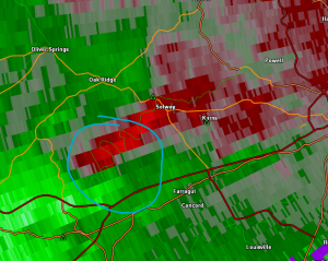
1691718117884.png

As you can see in the above image, there is clear sign of rotation in this storm. The timestamp on this radar scan is 2:09, 10 minutes before the tornado touches down. This rotation is pretty broad, so I can at least see where MRX is coming from not issuing a tornado warning at this point.
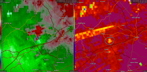
1691718367562.png

In the above image you can see noticeably tight rotation and a CC drop, which means there is a tornado on the ground and lofting debris into the air. CC, which stands for correlation coefficient, essentially measures the continuity of particles in the air using fancy radar polarization techniques. Lower CC values mean greater variation in sizes and shapes of particles in the air, indicating the potential for debris or hail. Whenever you see a CC drop coincident with rotation, as is the case here, that is a guarantee that a tornado is on the ground. Often times, the NWS will issue a "Tornado Warning" that states a damaging tornado is on the ground without even having actually observed a tornado visually, just based on this radar product.
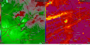
1691718768260.png
The following scan, as seen above, the area of rotation gets much more obscured. However, the CC drop became much more noticeable. A tornado warning still should have been issued, even at this point as there is still obviously a tornado on the ground.

In subsequent scans, the tornado fizzles out rapidly.

At the end of the day, humans are going to human and make mistakes. This was a pretty severe error. Thankfully, no lives were lost, but this definitely needs to be a learning opportunity for MRX going forward.
 
  • Like
Reactions: davethevol
Driving through Knoxville, there are parts on Lyons View that look like a tornado passed through as well. I wonder if one almost formed there.
 
Watch Alert!!!!!!

A Severe Thunderstorm Watch has been issued for the western half of East TN (Areas along and west of interstate 75) until 7:00 PM EST.
 
An EF2 tornado ripped through Spring Ridge subdivision and Wellington West subdivision off Hickey rd. It was neither a tornado watch nor a warning. I would like to tell the NWS to officially go F*** themselves as they were useless in a great time of need. I will never rely on you again. My property was irreparably damaged in the process.
 
An EF2 tornado ripped through Spring Ridge subdivision and Wellington West subdivision off Hickey rd. It was neither a tornado watch nor a warning. I would like to tell the NWS to officially go F*** themselves as they were useless in a great time of need. I will never rely on you again. My property was irreparably damaged in the process.
Bummer. Sympathies, Coug.
 
It’s a little early but any thoughts on Winter yet? I’m thinking we see a few decent snows this year, as in 3 or more with 2”+. No big snows but I’m thinking we will see an active weather pattern for a good portion of the season. I have no science behind that, just a gut feeling.
 
  • Like
Reactions: headhunter15
It’s a little early but any thoughts on Winter yet? I’m thinking we see a few decent snows this year, as in 3 or more with 2”+. No big snows but I’m thinking we will see an active weather pattern for a good portion of the season. I have no science behind that, just a gut feeling.

Agreed. I think we are due for a good winter!
 
It's not East TN but what an epic miss from the NHC on Hurricane Otis....

They forecast it making landfall at 85 mph. Less than 24 hrs later, it hit Acapulco at 170 mph..


According to this, East TN stands a better chance at seeing snow this winter.
 
  • Like
Reactions: hUTch2002

VN Store


Back
Top