East Tennessee Weather

Status
Not open for further replies.
18z GFS run with adjusted ratio:

post-11228-0-44299700-1454882057.png
 
I would be ecstatic if it snowed 2" in Knoxville but extremely happy if we got an inch.
 
For the southern valley I think we will see some snow showers for the next few days with little or no accumulation...1-2 in upper ET and on the KY border,3 inches on the plateau, 4-6 inches in the mountains
 
  • Like
Reactions: 2 people
Final Forecast:

After looking at all of the models, here's my thoughts on snow amounts through Wednesday evening.

Northern Valley and Plateau: 1-3, with locally higher amounts possible.

Central Valley: Dusting to 2 inches (Some areas of the valley could see a couple inches, while others see little in accumulation). I wouldn't be surprised if some of the ridges get 3 inches.

Southern Valley: Dusting. Unfortunately, folks southwest of Knoxville just won't see much in the way of accumulation.

Mountains and Northeast TN: 4-7 inches, with higher amounts possible in the highest peaks.
 
WBIR said a dusting to possibly 2 inches spread over the next 3 days in the valley with higher amounts in higher elevations.
 
If the sun being out now wasn't wierd enough, we actually have a chance of seeing isolated thunderstorms this afternoon before the snow. It's due to the very cold air aloft and decent convection. Here's the SPC's Thunderstorm map:

day1otlk_1300.gif
 
Also, everyone in the Valley is now under a Winter Weather Advisory. The Mountains have been upgraded to a Winter Storm Warning, where areas below 4000 feet (Gatlinburg, Cosby, ect) could see 3-6 inches while the peaks above 4000 feet could see 6-12 inches.
 
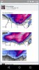
Before I post this model run, I need to add the following. This model is definitely subject to change and it should not be assumed at this time that the snowfall amounts will be accurate. We'll have to keep our eyes on this system.

Here's the 12z EPS control run for 9-10 days from today.

ZqtSMMK.png


It's showing about a foot of snow for the valley.

Sorry I should've been more specific. This one
 
Sorry I should've been more specific. This one

The following is someone's post on a weather board. The top model run is the blend of the 2 model runs below it. This was the 12z Euro run from yesterday.

Edit: Something I forgot to mention. When he says fantasy run, that means that this is an event that will happen in the long term and probably will change.
 

Attachments

  • Screenshot_2016-02-08-11-33-48.jpg
    Screenshot_2016-02-08-11-33-48.jpg
    45.3 KB · Views: 8
Last edited:
Something to keep an eye out for:

If you get hit with an isolated thunderstorm, you could see some small hail or graupel. It's because of the extremely cold air aloft in the upper levels. Also, temps will fall quickly in areas that get hit by a thunderstorm.
 
Was raining a few minutes ago mixed with sleet. It has stopped but I can see dark clouds moving back in.

Edit: this is straw plains area
 
Last edited:
I know we haven't gotten through this system yet, but I want to take a moment and discuss the system early next week that could produce major snowfall across the southeast, including East TN.

Firstly, we need to pump the brakes and take it with a grain of salt at this time. This system is still 7 days away, and weather can change pretty quick in that timespan.

Having said this, the model trends for the past few days have been very positive. If this system is still around this strength 3 days from now, and current model trends continue, then we can really start to watch it. I want everyone to wait until at least Thursday before you start to get excited about it.
 
Status
Not open for further replies.

VN Store


Back
Top