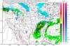
Unless there is a reversal just look for a combination of snow/rain next week..I would guess it would be a slushy mess in the valley with measurable snow in the higher elevations
Sunday Night
A 40 percent chance of snow. Cloudy, with a low around 25.
Washington's Birthday
Snow likely before 2pm, then rain and snow likely between 2pm and 4pm, then rain likely after 4pm. Cloudy, with a high near 37. Chance of precipitation is 60%.
Monday Night
Rain and snow likely, becoming all snow after 8pm. Cloudy, with a low around 31. Chance of precipitation is 60%.
Tuesday
A chance of rain and snow. Mostly cloudy, with a high near 43. Chance of precipitation is 40%.
Tuesday Night
A chance of rain and snow. Mostly cloudy, with a low around 31. Chance of precipitation is 30%.
Wednesday
Partly sunny, with a high near 53.