Vol knight
Text a Buddy!
- Joined
- Oct 2, 2013
- Messages
- 8,958
- Likes
- 3,141
Will one of you weather gurus explain how they get a feels like 28 when the temp is 22 with a wind speed between 10-15 mph? See below...
Mobile apps.....enough said, lol.
All jokes aside, weather apps on phones aren't usually that great. They typically only have one weather model that is used for their forecast. As you know, using one model isn't a great way to get forecasts beyond a couple days.
I'm starting to doubt we see these big accumulations early..TWC calling for less than an inch and NWS saying same for me
Sunday Night
Snow likely. Cloudy, with a low around 30. Southeast wind around 5 mph becoming southwest after midnight. Chance of precipitation is 70%. New snow accumulation of around an inch possible.
Washington's Birthday
Snow and sleet before 10am, then rain and snow between 10am and noon, then rain after noon. High near 40. East wind around 5 mph becoming west in the afternoon. Chance of precipitation is 80%.
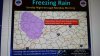
...WINTER STORM WATCH IN EFFECT FROM SUNDAY AFTERNOON THROUGH
MONDAY AFTERNOON...
THE NATIONAL WEATHER SERVICE IN MORRISTOWN HAS ISSUED A WINTER
STORM WATCH...WHICH IS IN EFFECT FROM SUNDAY AFTERNOON THROUGH
MONDAY AFTERNOON.
* EVENT...SNOW AND SLEET ACCUMULATIONS OF 2 TO 5 INCHES ARE
EXPECTED IN THE NORTHERN CUMBERLAND PLATEAU...NORTHERN TENNESSEE
VALLEY...AND SOUTHWEST VIRGINIA. HIGHER ELEVATIONS MAY SEE
BETWEEN 3 AND 6 INCHES OF SNOW AND SLEET ACCUMULATION.
* TIMING...SNOW IS EXPECTED TO BEGIN ACCUMULATING AROUND MIDDAY
SUNDAY...WITH A MIX OF SNOW...SLEET...AND RAIN LATE SUNDAY NIGHT
AND MONDAY MORNING BEFORE CHANGING TO ALL RAIN MONDAY AFTERNOON.
* IMPACTS...SNOW-COVERED ROADS WILL MAKE DRIVING CONDITIONS
HAZARDOUS.
PRECAUTIONARY/PREPAREDNESS ACTIONS...
A WINTER STORM WATCH MEANS THERE IS A POTENTIAL FOR SIGNIFICANT
SNOW...SLEET...AND/OR ICE ACCUMULATIONS. FUTURE DRIVING
CONDITIONS MAY BECOME HAZARDOUS...SO CONTINUE TO MONITOR THE
LATEST FORECASTS.